Researchers at the University of North Cornwall are working on a new project indicating that much of Cornwall's road network was created by elephants trampling the native vegetation.
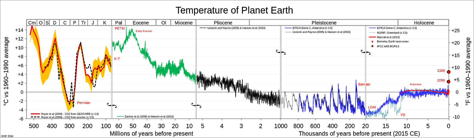
Elephants lived in the British Isles, including Cornwall during the Ipswichian interglacial (also known as Eemian) epoch between 130,000 years ago and 115,000 years ago, when temperatures were similar to or slightly warmer than at present, before the last glacial period.
See the following link by George Monbiot:
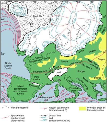
www.monbiot.com/2015/06/15/thinking-like-an-elephant/Elephants will have made tracks over most of Britain, however in much of this area, the tracks would surely have been erased by ice sheets in the Last Glacial Maximum.
 |
| Ice sheets in Europe during the Last Glacial Maximum |
 |
| Cornwall however was not glaciated, so tracks made by elephants in the 130-115kyr BP interglacial could have survived, and may have continued in use by herds of migrating woolly mammoth that visited Cornwall in the summer to graze, and potentially the early Cornish who hunted them. |
 |
| Woolly mammoth were able to reach their summer pastures in Cornwall by crossing the Channel river - either in sections where it was broad and shallow, or during the spring before the ice melted. |
Elephants travelling on their favourite routes in Cornwall would over time create enduring tracks by trampling and browsing of vegetation, and compaction of soil. These routes would be more easily followed by other wildlife, and eventually humans. There would also have been additional resources due to the distribution of plant seeds and improvement of soil nutrients by elephant droppings.
The research used a
download of the secondary, tertiary and unclassified road network in Cornwall, from OpenStreetMap. Primary and trunk roads were ignored since they are liable to be on modern alignments.
 |
| Were some of these roads built by elephants? |
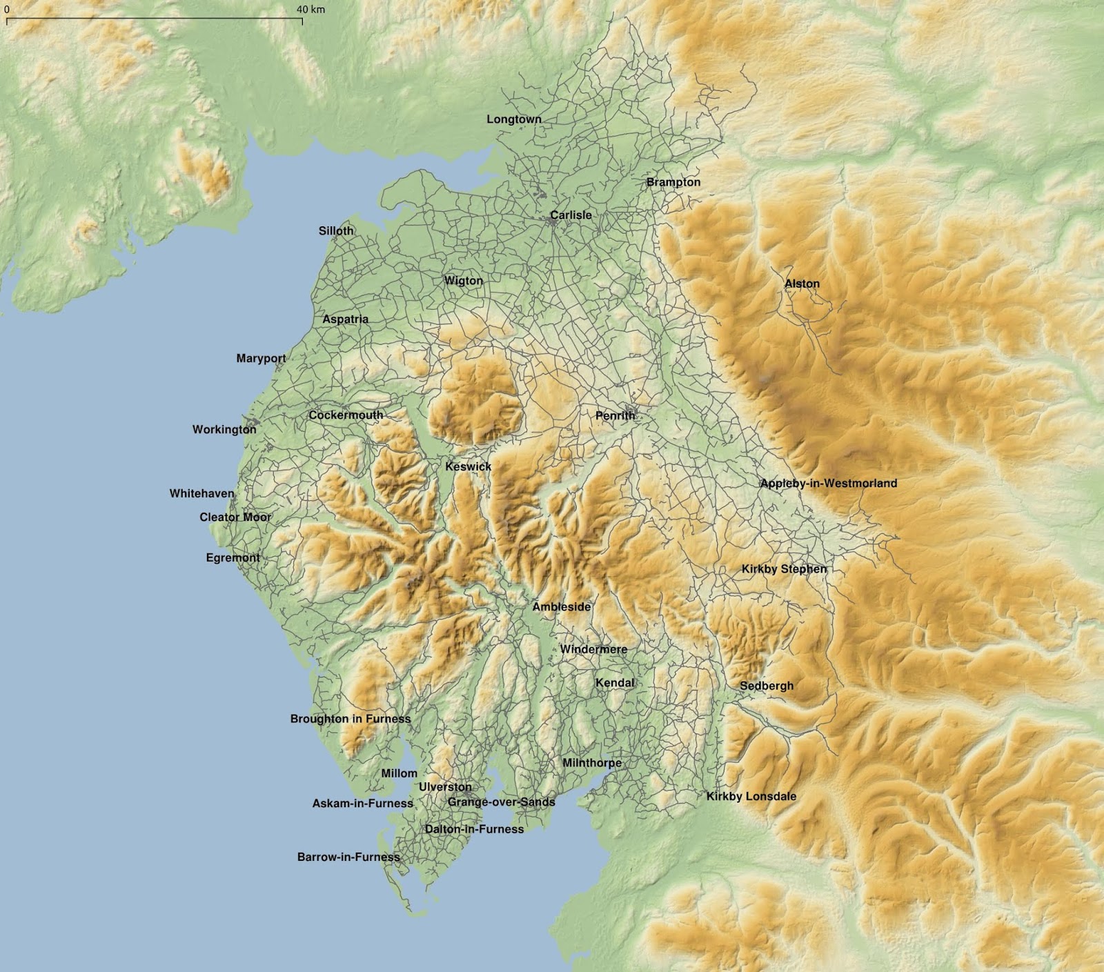
Cornwall was contrasted with Cumbria, since any elephant tracks would be expected to be erased there during the last glacial period.
 |
| Cumbria in northern England was covered in thick ice sheets during the last glacial period, so it is presumed that any traces of elephants from the previous interglacial are erased. |
 |
| Northern Wales was similarly covered by a thick ice sheet. |
The secondary, tertiary and unclassified roads have various numbers of features in the different areas:
- Cornwall - 9730
- Cumbria - 9704
- Wales - 30775
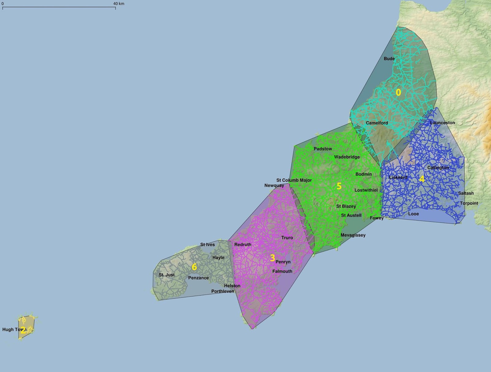
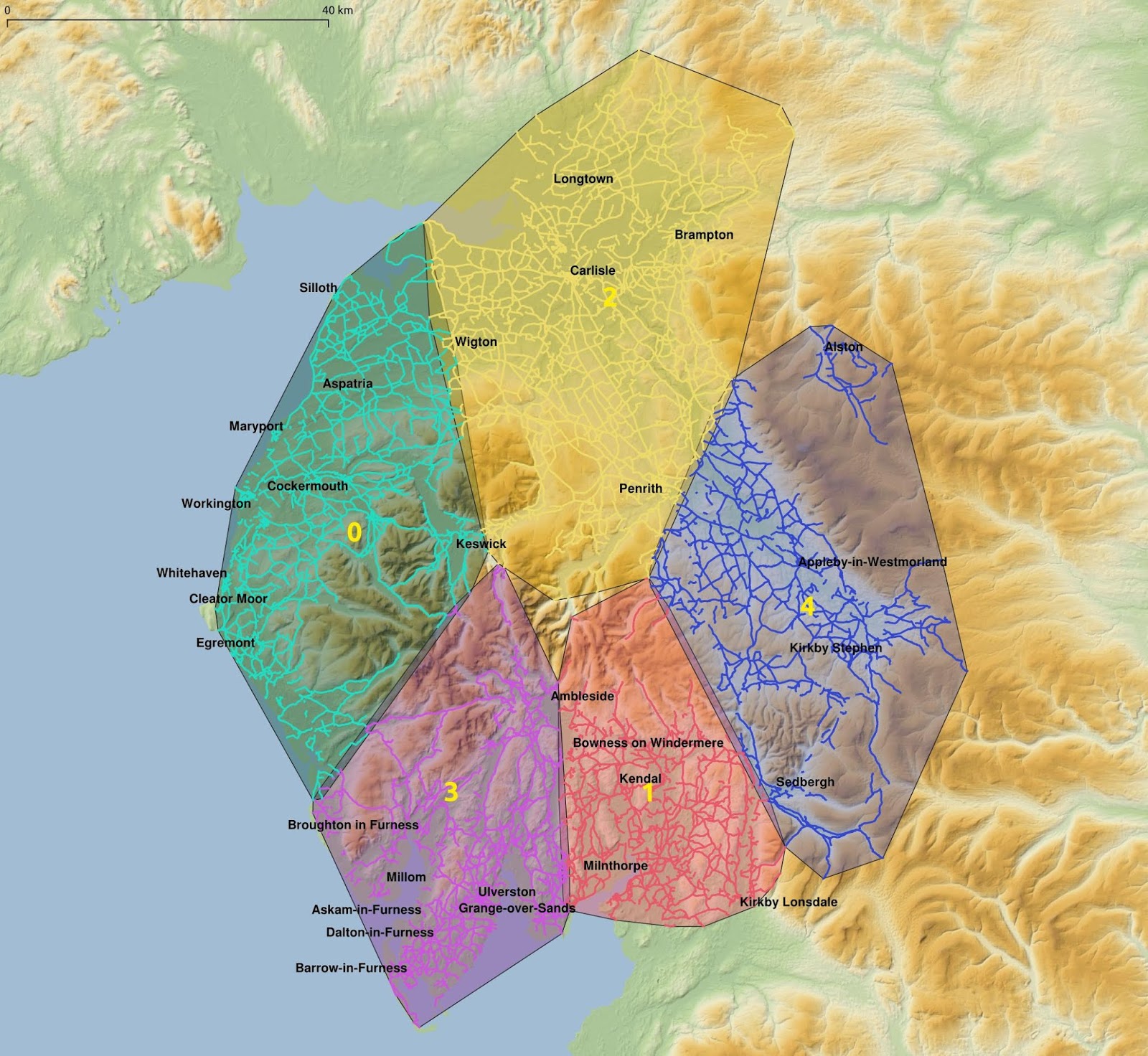
Using K-means clustering, showing 5 clusters in Cornwall and Cumbria:
 |
| there are the Isles of Scilly, and a spurious feature off the map, so there are really 7 clusters here |
 |
| 5 K-means clusters of the minor road network in Cumbria |
The numbers of features, total road length, mean and median length in the clusters are:
Cornwall:
- 0: 1001, 846km, 845m, 455m
- 3: 2689, 1406km, 523m, 257m
- 4: 2034, 1375km, 676m, 403m
- 5: 2597, 1597km, 615m, 293m
- 6: 1308, 596km, 456m, 215m
Cumbria:
- 0: 2104, 1202km, 571m, 232m
- 1: 1754, 802km, 457m, 213m
- 2: 2468, 1929km, 782m, 344m
- 3: 1793, 861km, 480m, 213m
- 4: 1585, 914km, 576m, 241m
Cornwall has 2 clusters (0 and 6 in the far west, and north Cornwall respectively) that are much smaller in terms of number of features than the other 3, indicating that certain clusters, notably the two largest clusters, labelled 3 and 5 have a dense road network which originated when elephants followed river valleys in their migrations in search of food sources.
Cluster 0 in North Cornwall is less dense possibly due to episodic glaciation of Bodmin Moor and surrounding areas erasing elephant tracks.
Cumbria in contrast has relatively evenly sized clusters, apart from cluster 2 which is larger than the rest, correlated with a flatter topography than the rest of the area.
The remaining clusters are similar in number of features and average line length. This is to be expected due to the erasure of the pre-glacial elephant migration routes.
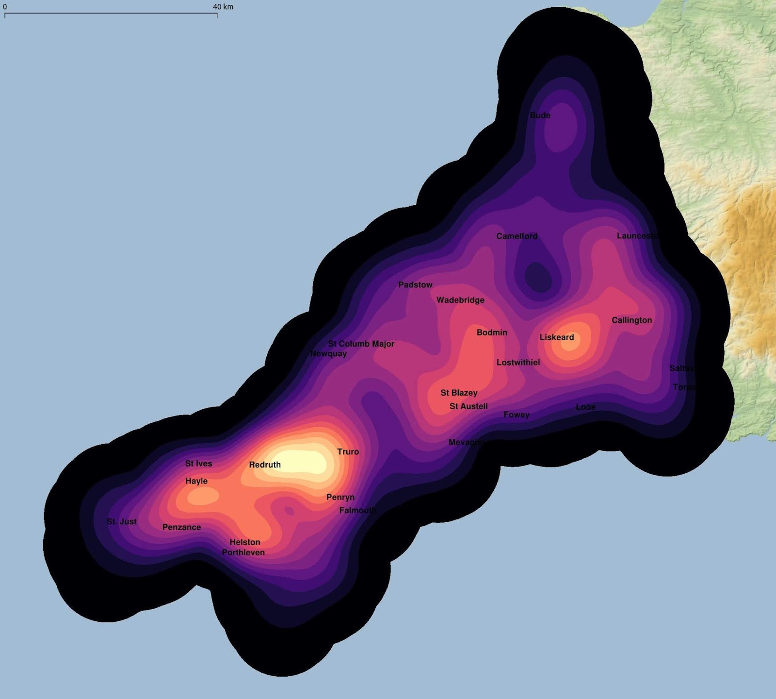
Heatmap of road intersections (10km kernel size)
 |
| In Cornwall, there is a strong variation in the regional distribution of road junction density due to differences in the density of the elephant migration routes. It may be supposed that the area between Truro, Redruth and Penryn was highly favourable to elephants during the 130-115kyr BP interglacial. |
 |
| In Cumbria, there is a lower density of road intersections due to the erasure of previous interglacial elephant migration tracks during the last glacial period. |
 |
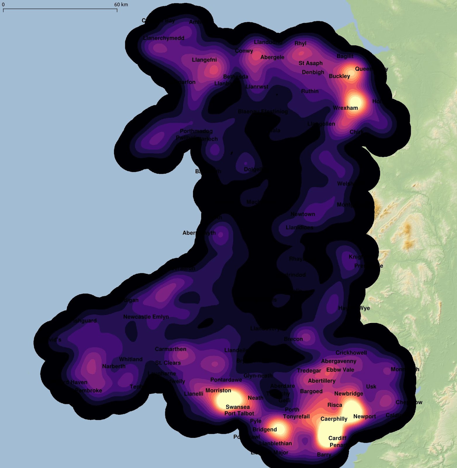
| The secondary, tertiary and unclassified road network in Wales, in 15 clusters to keep the average number of features broadly comparable to the previous work. |
 |
| Outside the major urban areas, the density of the road junctions are markedly lower in Wales than in Cornwall, indicating elephant tracks were erased in the last glacial maximum. |
ConclusionThe relative high density of the Cornish minor road network is shown in this work to originate in tracks created by elephants in the 130-115 kyr BP interglacial, and potentially maintained through the glacial period by seasonally migrant wooly mammoth grazing the tundra vegetation available in Cornwall in the summer during the glacial period. In contrast, in areas that were glaciated including Wales and Cumbria the elephant tracks were erased, resulting in a different road network topology.
 Elephants travelling on their favourite routes in Cornwall would over time create enduring tracks by trampling and browsing of vegetation, and compaction of soil. These routes would be more easily followed by other wildlife, and eventually humans. There would also have been additional resources due to the distribution of plant seeds and improvement of soil nutrients by elephant droppings.