Skrifennow
My blog, imported from Blogger and converted using Jekyll.
« Prev
1
2
3
4
5
6
7
8
9
10
11
12
13
14
15
16
17
18
19
20
21
22
23
24
25
26
27
28
29
30
31
32
33
34
35
36
37
38
39
40
41
42
43
44
45
46
47
Next »
Lots of planets have a North
Here is the North of Mars, showing the Mars Express High Resolution Stereo Camera tiles used in my MSc dissertation, colour-coded by elevation, but also with the output of the Bayesian classifier measuring the similarity to Colin Souness's glacial form.
This is possibly a bit too colourful and the classifier output isn't really useful at this scale. The segmented DTM has red indicating similarity to glacier 'head' areas, green for 'context' areas (9x area of extent) and blue for extents.
I use QGIS to blend the elevation with an underlying nadir image also from HRSC with "Hard Light". I am not sure whether the developers of QGIS intended the Red Dwarf reference.
The coordinates are in an equirectangular projection in metres optimised for a standard latitude of 40°.


The Lost land of Lyonesse revisited
In a previous post, I mentioned the work of Shennan and Horton (2002) about sea level change around Britain through the Holocene.
I showed a visualisation of the West Cornwall coastline as it may have been around 12,000 years before present.
After downloading further bathymetry via the UKHO INSPIRE portal, I present an updated version covering the whole area around Cornwall.
Much of this came as .csv point data, which I had to grid, and use the QGIS Concave Hull plugin from the Processing toolbox to restrict the interpolated grid to where there was data.
In some areas, there are gaps in what is currently available at high resolution so it falls back to low-resolution data.
Based on my reading off the graphs in Shennan and Horton, the sea level rise at this time should be similar across the area covered here:

It is clear there were substantial areas of land that were disappearing in the millenia after the reoccupation of Britain after the last glacial maximum (with this map corresponding to the cold spell of the Younger Dryas).
In the period of time, between 12kyr BP and 8kyr BP sea level rose by 20m, which corresponds to half a metre every century.
Especially in the large expanses of gently sloping terrain off the north coast, it would be likely that coastal retreat would have been noticeable by people within a single lifetime.
A version speculating about woodland colonising the lowlands:

I showed a visualisation of the West Cornwall coastline as it may have been around 12,000 years before present.
After downloading further bathymetry via the UKHO INSPIRE portal, I present an updated version covering the whole area around Cornwall.
Much of this came as .csv point data, which I had to grid, and use the QGIS Concave Hull plugin from the Processing toolbox to restrict the interpolated grid to where there was data.
In some areas, there are gaps in what is currently available at high resolution so it falls back to low-resolution data.
Based on my reading off the graphs in Shennan and Horton, the sea level rise at this time should be similar across the area covered here:
| Site Number | Site Name | Lat | Long | RSL 1kyr | RSL 2kyr | RSL 3kyr | RSL 4kyr | RSL 5kyr | RSL 6kyr | RSL 7kyr | RSL 8kyr | RSL 9kyr | RSL 10kyr | RSL 11 kyr | RSL 12 kyr |
| 42 | Pembroke | 51.8 | -5.1 | -0.8 | -1.6 | -2.4 | -3.2 | -4 | -9.2 | -14.4 | -19.6 | -24.8 | -30 | -35.2 | -40.4 |
| 43 | Glamorgan | 51.5 | -3.7 | -2 | -4 | -6 | -8 | -10 | -13.6 | -17.2 | -20.8 | -24.4 | -28 | -31.6 | -35.2 |
| 51 | Devon | 50.4 | -3.5 | -1 | -2 | -3 | -4 | -5 | -10 | -15 | -20 | -25 | -30 | -35 | -40 |
| 52 | Cornwall | 50.2 | -5.5 | -1.4 | -2.8 | -4.2 | -5.6 | -7 | -11.6 | -16.2 | -20.8 | -25.4 | -30 | -34.6 | -39.2 |

It is clear there were substantial areas of land that were disappearing in the millenia after the reoccupation of Britain after the last glacial maximum (with this map corresponding to the cold spell of the Younger Dryas).
In the period of time, between 12kyr BP and 8kyr BP sea level rose by 20m, which corresponds to half a metre every century.
Especially in the large expanses of gently sloping terrain off the north coast, it would be likely that coastal retreat would have been noticeable by people within a single lifetime.
A version speculating about woodland colonising the lowlands:

Ebrenn y'n Nos mis-Hedra 2015
This is a transcript of the October 2015 episode of Ebrenn y'n Nos (The Sky at Night in Cornish) which was broadcast in #243 of Radyo an Gernewegva.
Dydh da. Ottomma rann nowydh kevres “Ebrenn y'n nos” mis-Hedra.
Dhe mis-Hedra yma an rannnevesow kynyav orth aga omdhiskwedhes.
 |
| 11 y'n nos, yn kres mis-Hedra |
Onan an moyha kler yw an pedrek Pegasus. Pegasus yw rannneves bras ughel y'n ebrenn dres an kynyav. Ev yw margh-nija diworth henhwedhlow Grek. Nessa dhodho yw rannnves arall Andromeda. Y'n ranneves ma yma an Galaksi Andromeda (Messsier 31). M31 yw an galaksi meur ogassa dh'agan galaksi. Ev yw martesen nebes brassa es agan galaksi, hag a'n jeves galaksiow loor ow resegva a-dro dhodho. Yma M31 dihaval orth an brassa niver a galaksiow, drefenn hi dhe'gan nesa dhe'n kevradh 300km pub eylenn. Dell usys an galaksiow a wra mos dhe-ves diworthyn hag an ollvys dhe omlesa. Yn pymp bilvil blydhen ow tos ev a wra junya gans agan galaksi ha furvya unn galaksi veur. Na borth own drefenn yma an sterennow mar bell diworth aga honan ha'n galaksiow a wra mos dres aga honan, bys dhe'n dhew galaksiow dos ha bos onan.
 |
| Diworth Adam Evans dre Wikimedia Commons |
Yma galaksi bras yn resegva a-dro dhe M31, ogas dhe degves rann braster M31. Henn yw an galaksi M33, y'n ranneves Triangulum. M31 yw gweladow yn es dre dhewlagas nooth, ha da yw yn diwlagattell yn ebrenn tewl. M33 yw kalessa dhe weles, mes y hyll bos gwelys dre dewlagas nooth mars yw an ebrenn pur dewl, martesen mars os ta war Woon Bren po Lysardh. Gans pellwelerow pur vras kepar hag an Keck in Hawai'i y hyll bos gwelys an sterennow yn M31 ha M33, ha pella, kammnevesow anedha, dhe dhyski moy a-dro dhe'n galaksiow ma.
An loor:
Kwartron diwettha yw an 4a mis-Hedra, loor nowydh yw 12ves mis-Hedra, kynsa kwartron vydh 20ves mis-Hedra, ha'n loor leun vydh dhe'n 27ves.
An planetys:
Mergher yw gweladow yn soth-est y'n ebrenn bora, kyns an howldrevel, gans ystynnans moyha dhe'n West dhe'n 16ves mis-Hedra, mes ny vydh marnas nebes degreow a-vann an gorwel kyns an howldrevel. Gwener yw y'n ebrenn bora ynwedh, marthys ughella ha mos dh'y ystynnans moyha dhe'n West dhe'n 26ves mis-Hedra. Meurth yw yn ebrenn bora ynwedh, ow trehevel y'n Est a-dro dhe 4 eur y'n bora. Ev yw yn rann pell diworthyn yn y resegva ha ganso braster 1.8. Ev vydh marthys splanna Gwaynten nessa.
 |
| Planetys kyns an howldrevel (16ves mis-Hedra) |
Yma New Horizons hwath ow tannvon imajys ha data diworth y dresnijans Pluton an hav ma. Yma Rosetta hwath ow studhya an komet67P/Churyumov-Gerasimenko mes soweth ny wrug kestava gans an tirell Philae arta.
Yma China ow pesya hwilas an loor. I a vynn tira robot war denewenpell an loor, erbynn 2020 gans rosyell kepar hag a wrussons i tira Chang'e 3 ha'n rosyell Yutu war an denewen nes yn 2013. I a vynn dannvon robot a wra kemmer sampelha'y dhehwelesdhe'n norvys y'n termyn a dheu, martesen ow lonchya yn 2017.http://spaceflightnow.com/2015/09/21/china-aims-for-landing-on-moons-far-side-by-2020/http://moon.bao.ac.cn/multimedia/img2dce3.jsp
Y fydh an nessa efanvos Europek dhe Veurth, ExoMars 2016, delatys gans 2 vis. Ev a wra lonchya yn mis-Meurth yn le mis-Genver2016 ha vyajya 7 mis dhe Veurth, dhe studhya y ayrgylgh ha'n gewer gans an "Trace Gas Orbiter" (Resegvell Gas Tanow)ha tira an direll Schiaperelli. http://spaceflightnow.com/2015/09/20/launch-of-european-mars-mission-delayed-two-months/
An efanvos ma yw profyans yn hwir rag an efanvos ExoMars 2018, a wra tira rosyell war eneb Meurth.
Yma neppyth a-dro dhe Veurth diworth NASA, yn Kembrek. Yma gwiasva "Beautiful Mars" gans imajys diworth resegvell "Mars Reconnaisance Orbiter", ha neppyth y'ga hever treylys yn lies yeth, ow komprehendya Kembrek: http://beautifulmars-welsh.tumblr.com/po http://www.uahirise.org/cy/.
Chons da kavos gewer da hag ebrenn kler. Bys nessa prys.
Probably not the Aurora Borealis
From time to time, the Aurora Borealis can be visible from the UK, and the Twitter accounts AuroraWatch UK and BGS Aurora Alert can be useful in getting warning of this. It is relatively rare that it is visible as far south as Cornwall, but I did have a look at around 11pm BST on 8th October and took some not very convincing pictures of the northern sky, where there was mist illuminated by artificial lights.

More pictures at my Google+ album.

More pictures at my Google+ album.
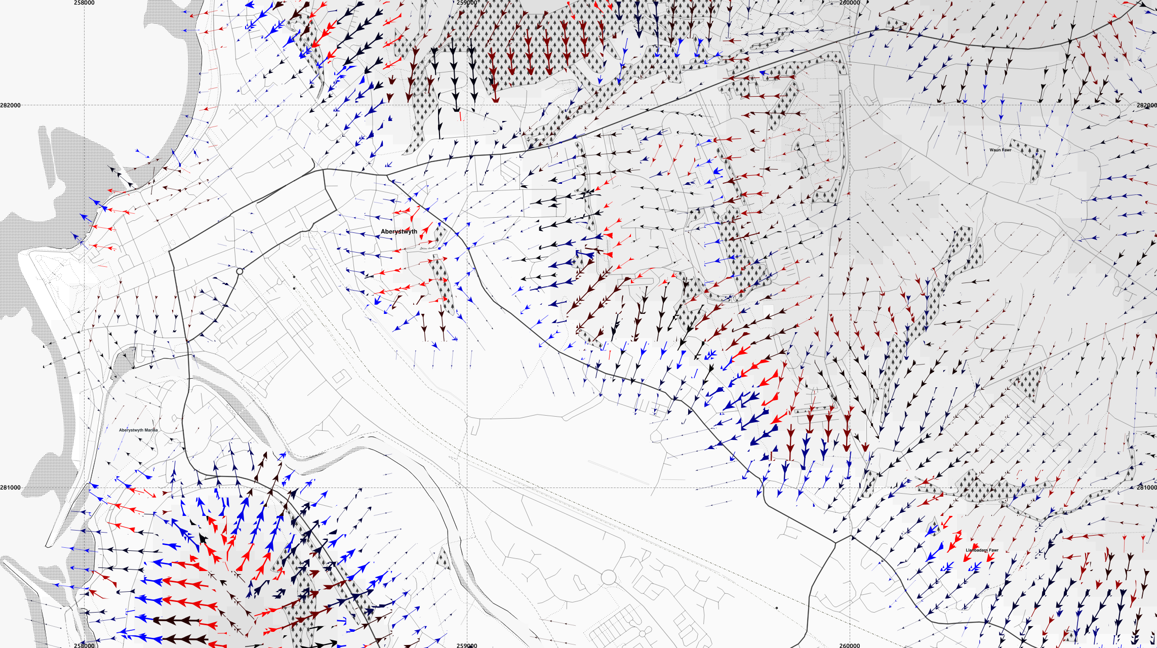
Maps of Wales with slope arrows
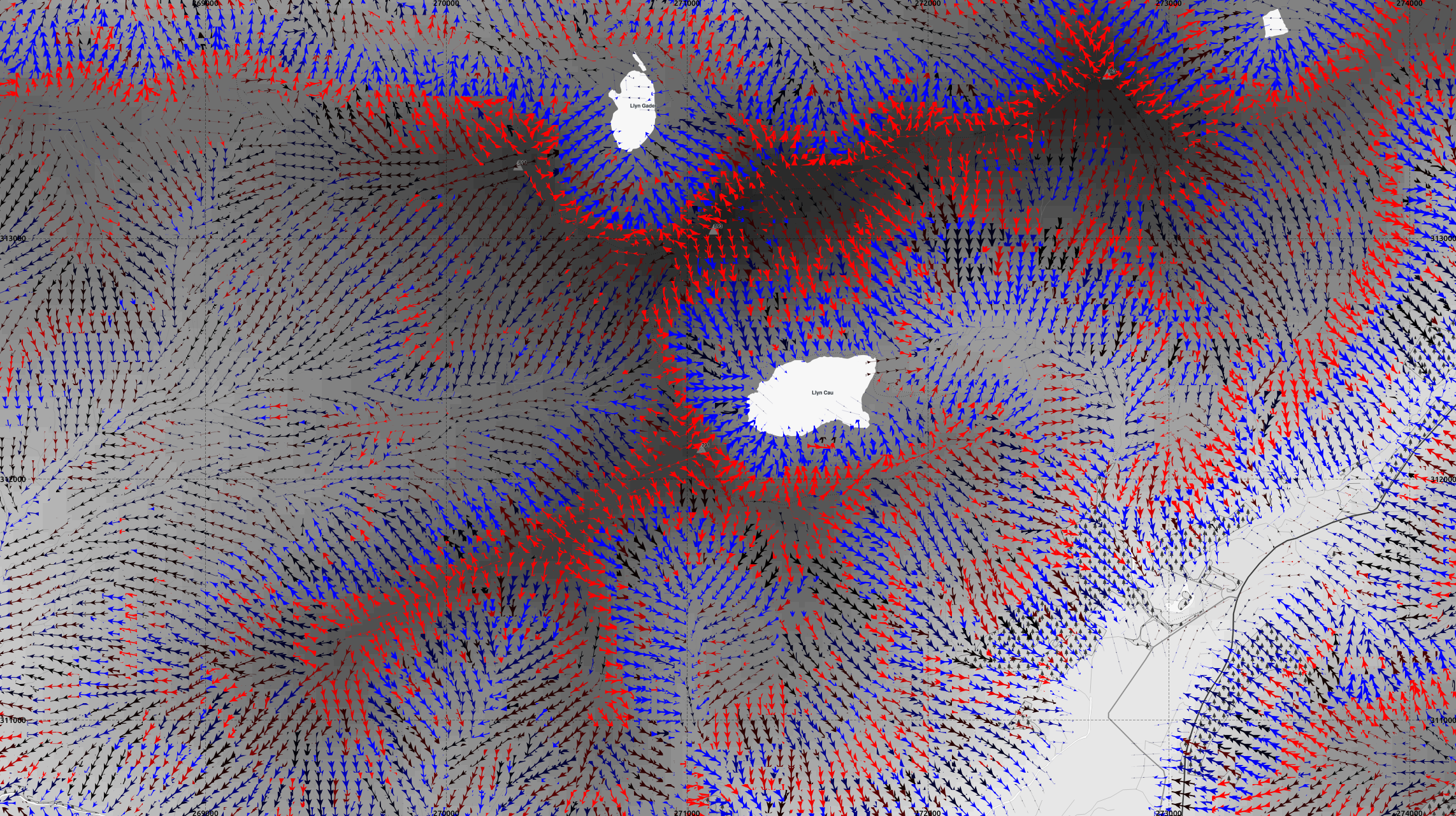
Here are a couple of maps of Aberystwyth, and Cadair Idris, with the RSGISlib segmented digital elevation model.
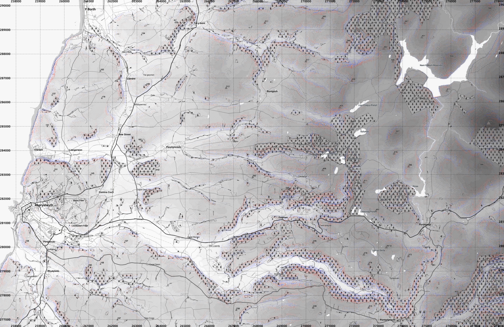
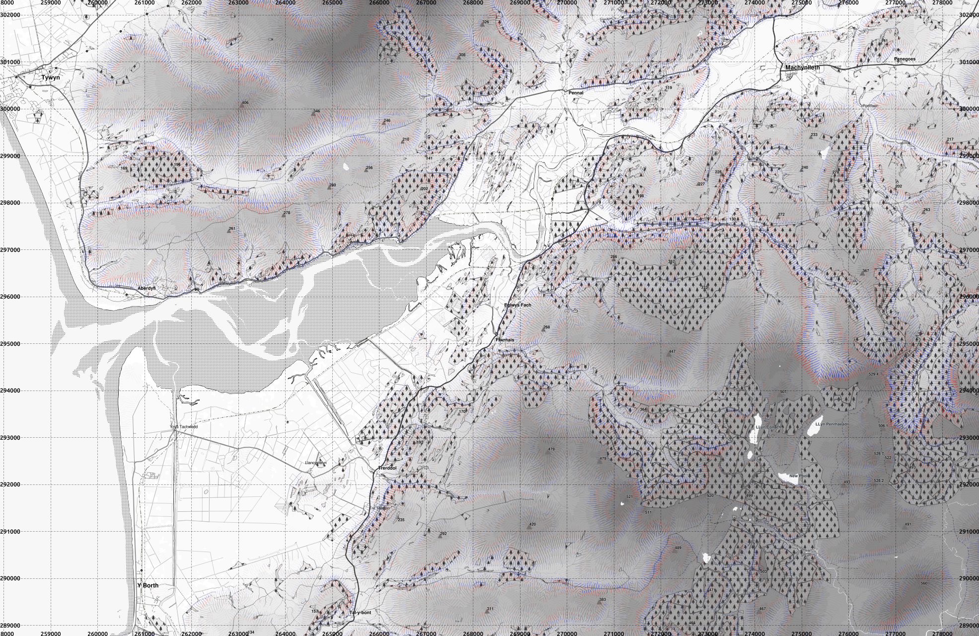
Slope direction is shown by arrows, and coloured in the same scheme as previously with thicker arrows for steeper slopes, and longitudinal curvature indicated with convex slopes red and concave blue.
1:10000 seems about the limit of the smallest scale that QGIS will cope with the arrowed lines. Beyond that the computer just hangs - slope lines without arrows can be plotted without problem.
To readers: are there any requests of areas you would like to see?
The processed data currently includes the following area though I also have the whole of British Isles (except most of Shetland) DEM from 1 arcsec SRTM (and could download anywhere up to 60° latitude) but not processed to create slope curvature layers and segmented.

Slope direction is shown by arrows, and coloured in the same scheme as previously with thicker arrows for steeper slopes, and longitudinal curvature indicated with convex slopes red and concave blue.
1:10000 seems about the limit of the smallest scale that QGIS will cope with the arrowed lines. Beyond that the computer just hangs - slope lines without arrows can be plotted without problem.
 |
| Aberystwyth town centre, and the university campus. full-res version |
 |
| Cadair Idris. This is a textbook example of a glacial landscape in the British Isles. full-res version |
 |
| Aberystwyth area and Rheidol Valley. full-res version |
 |
| Dyfi Estuary showing Borth, Tywyn and Machynlleth. full-res version |
The processed data currently includes the following area though I also have the whole of British Isles (except most of Shetland) DEM from 1 arcsec SRTM (and could download anywhere up to 60° latitude) but not processed to create slope curvature layers and segmented.

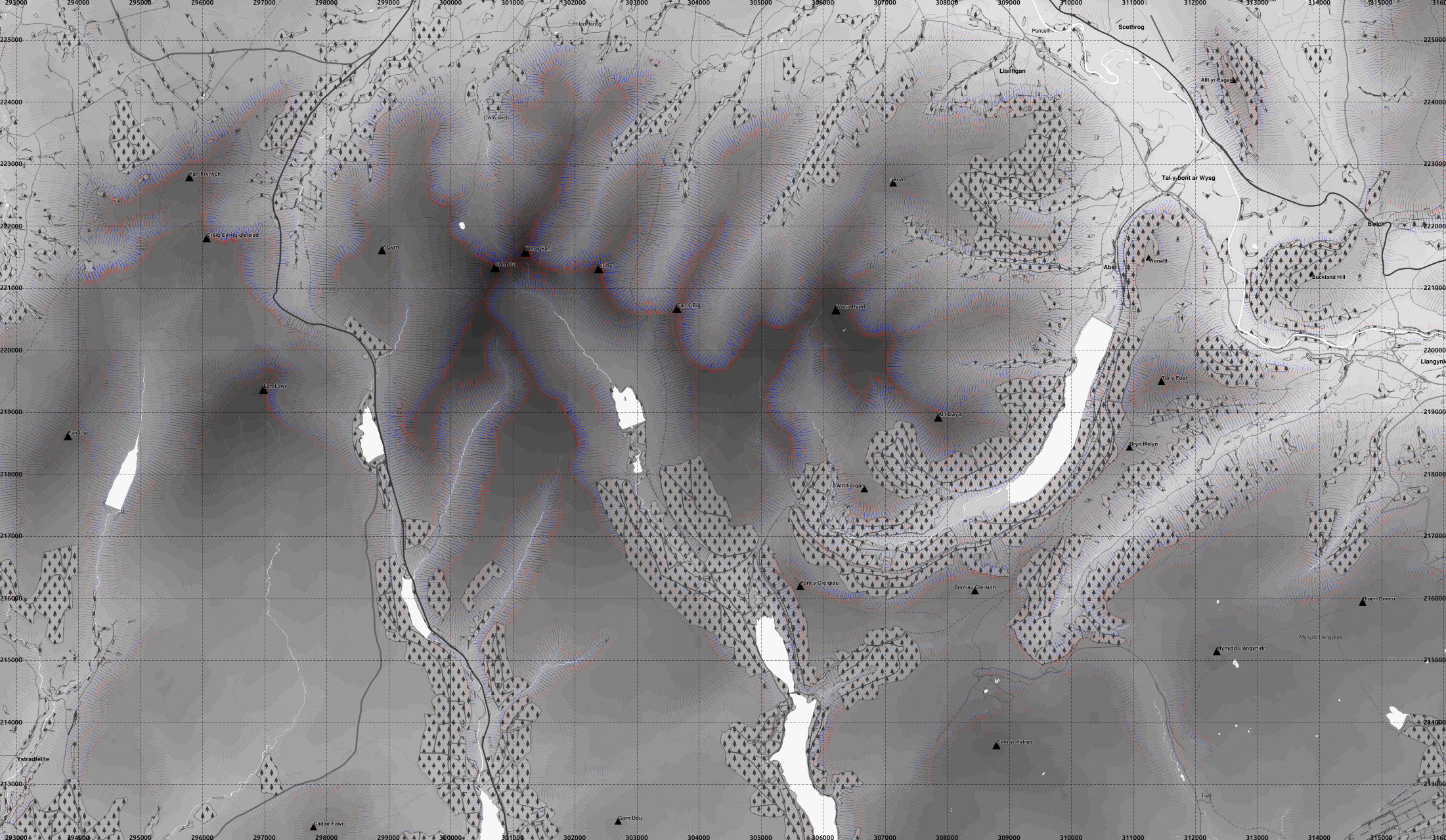
Pen-y-fan area, Brecon Beacons
 |
| Pen-y-fan main summit to the right of centre, showing the slopes convex at the top, but generally concave further down. full-res version |
 |
| Broader context at 1:40000. full-res version |
« Prev
1
2
3
4
5
6
7
8
9
10
11
12
13
14
15
16
17
18
19
20
21
22
23
24
25
26
27
28
29
30
31
32
33
34
35
36
37
38
39
40
41
42
43
44
45
46
47
Next »