Skrifennow
My blog, imported from Blogger and converted using Jekyll.
« Prev
1
2
3
4
5
6
7
8
9
10
11
12
13
14
15
16
17
18
19
20
21
22
23
24
25
26
27
28
29
30
31
32
33
34
35
36
37
38
39
40
41
42
43
44
45
46
47
Next »
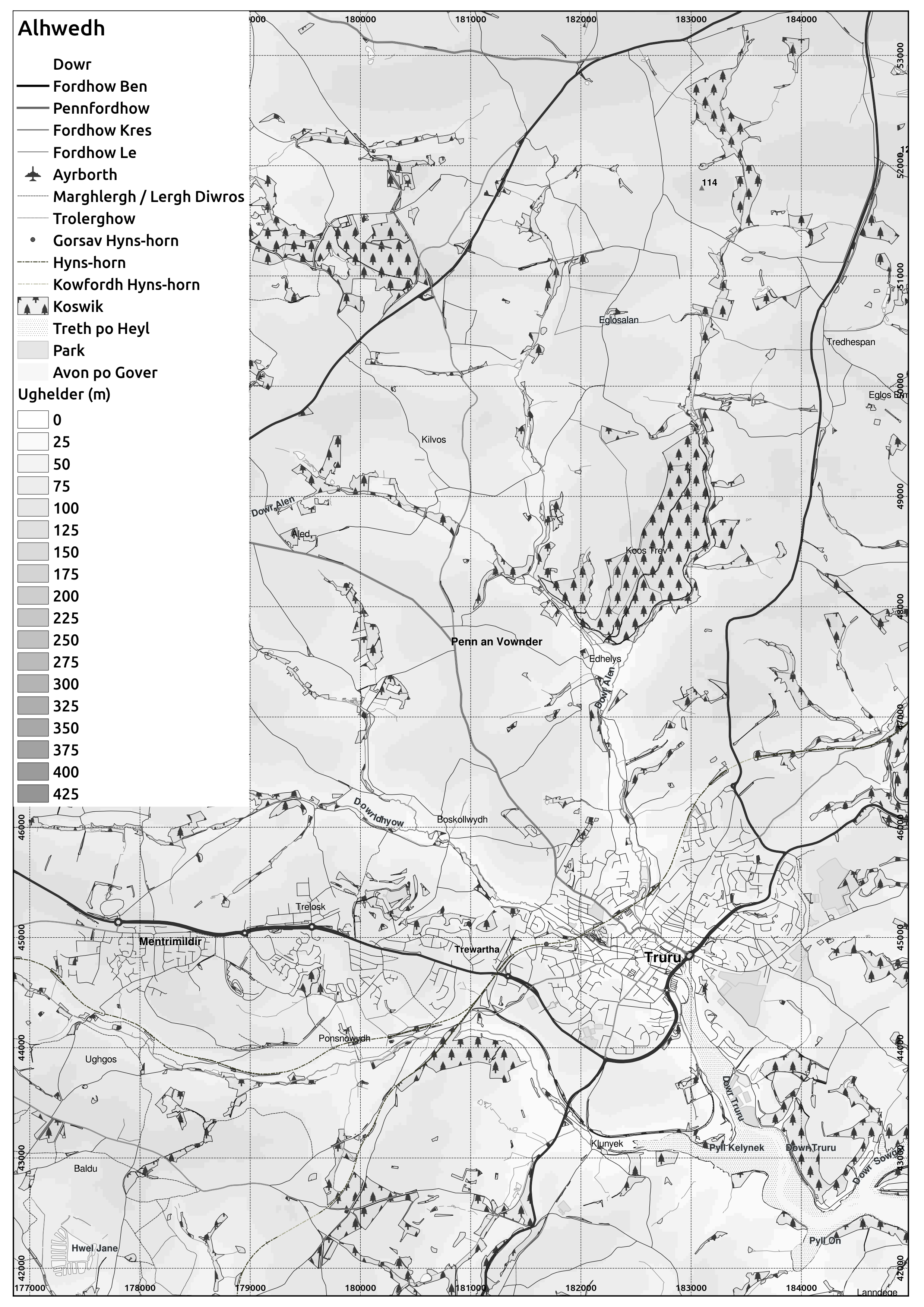
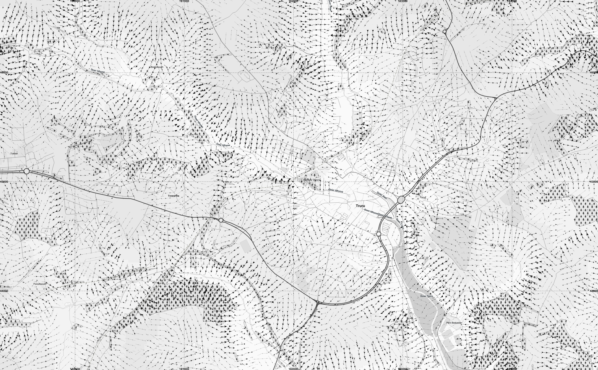
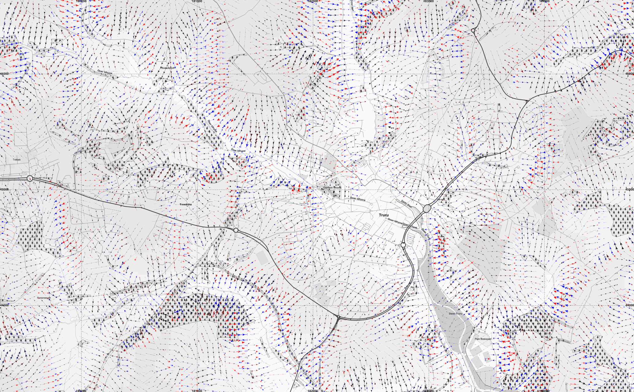
A greyscale version of my maps in Cornish
I have made a greyscale version of the maps in Cornish I have been working on.
Here is an extract from the Truro area:
Here is an extract from the Truro area:
 | ||||
| Cornish placenames from MAGA Placename and Signage Panel and the book by Craig Weatherhill. Some names of geographic features are my own translations of English names. Any errors are my own responsibility. large version |
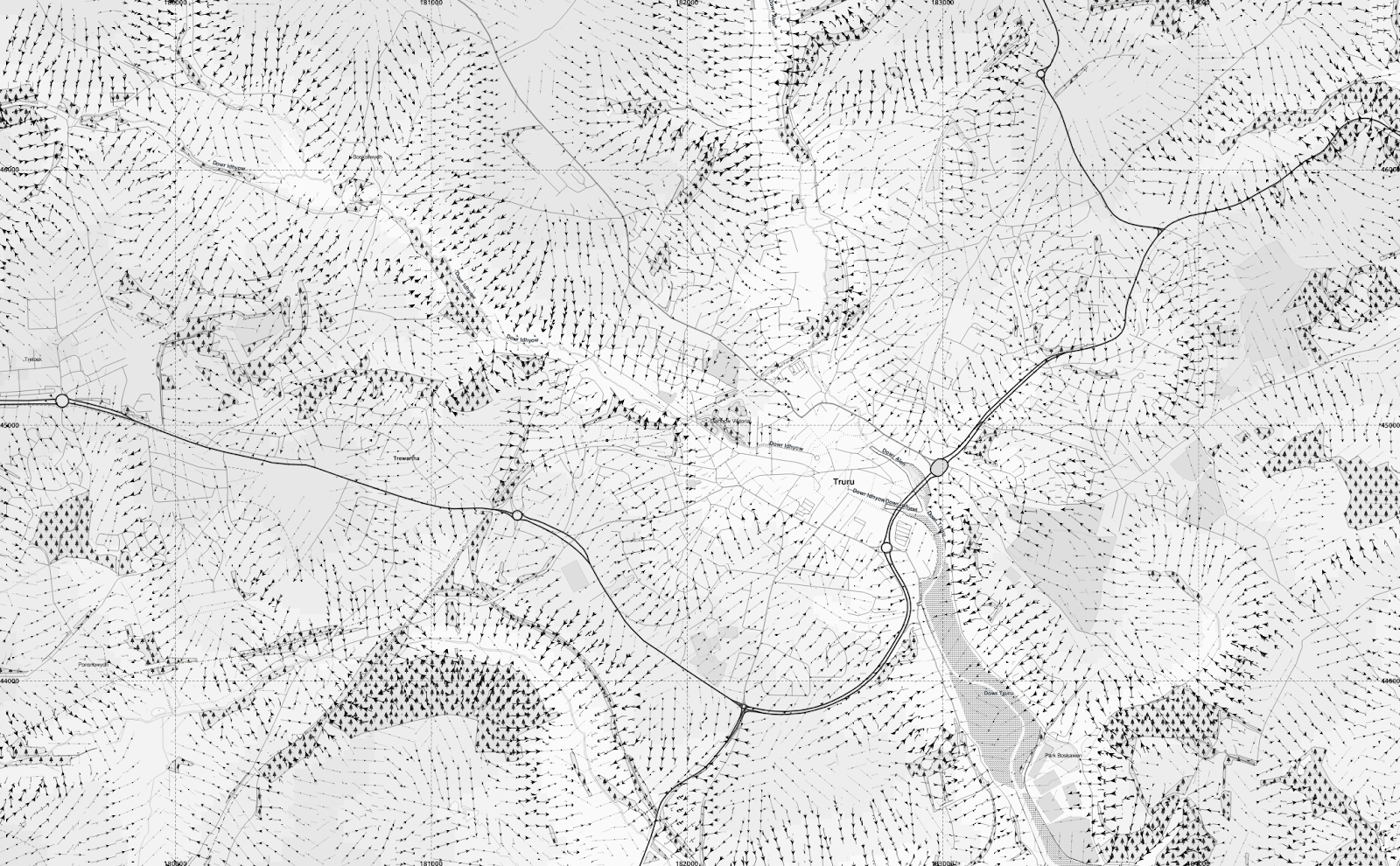 |
| Adding arrows to indicate the (downward) slope direction using the segmentation method described in earlier posts. large version |
 |
| Keeping the map greyscale but showing longitudinal curvature of the slope with convex slopes in red and concave in blue. large version |
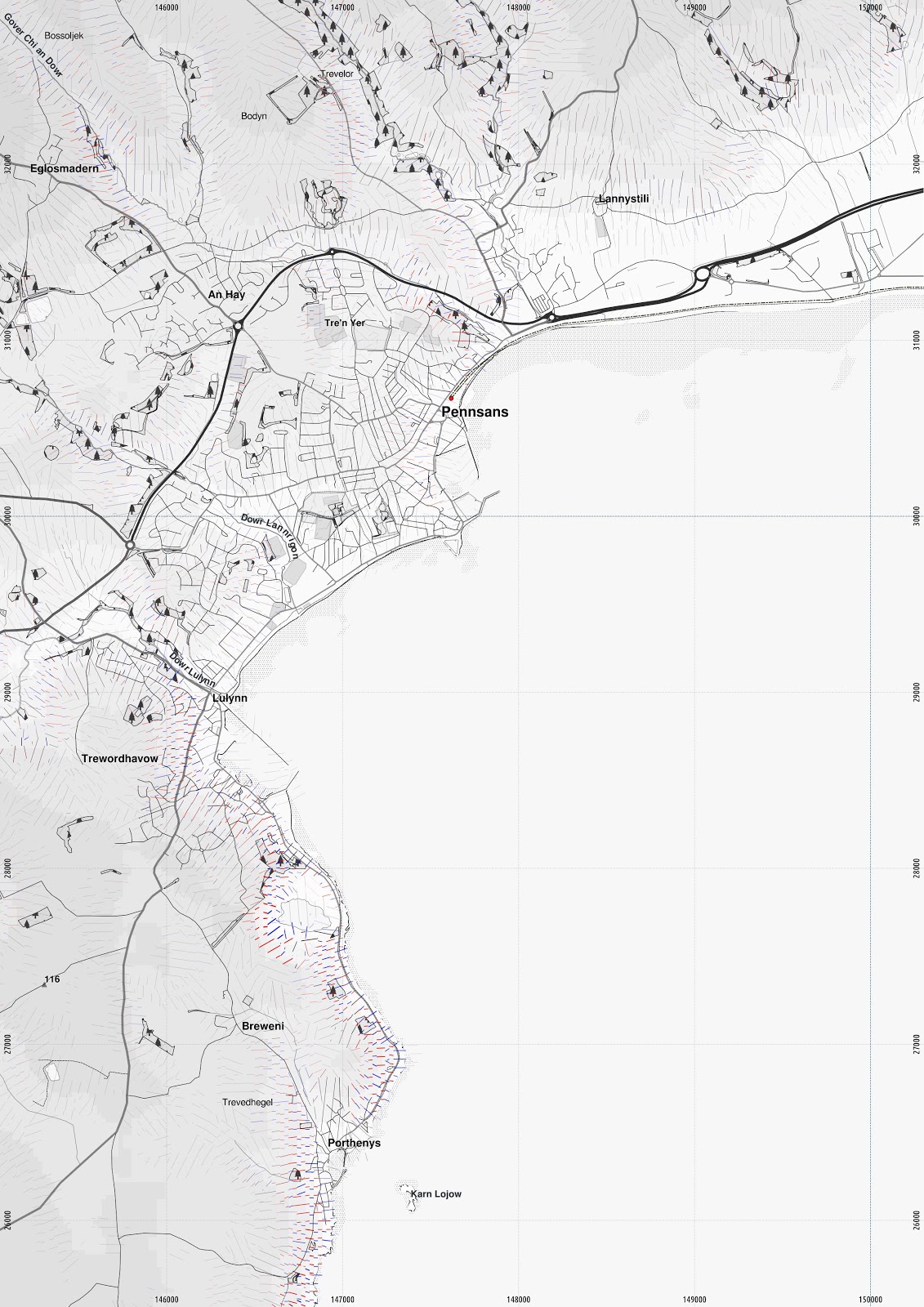 |
| Penzance. Unfortunately using the arrows tends to make QGIS run very slowly and crash for larger maps. larger version |
Akademi Kernewek
Yth esen vy yn kuntelles an myttin ma, avel 'Forum Yeth Kernewek - Cornish Language Forum' ow keskewsel gans pobel diworth Konsel Kernow, eseli bagaosow yeth ha kernewegoryon erell, a-dro dhe towlennow chanjya furv a wra Konsel Kernow owth oberi a-rag Kernewek.
Nyns o pubonan unnverhes an chanj yw da, nebes a leveris y fia gwell kavoes arghasans hir-dermyn hag ena gorra framweyth nowydh, wosa chanjya an framweyth kyns ambos anodho, mes ny vynnav skrifa meur a'n mater na.
Yma towlenn sevel 'Akademi Kernewek' dhe pesya an ober gans gerlyver FSS, henwyn leow, h.e.
Yma nebes Akademiow Yeth a-dro dhe'n bys, rol diworth Wikipedia. An huni yn Latvia a wrug seulabrys dewis ger rag 'hipster'.
Yma Akademi Yeth yn Pow Chekk, an brassa rann a'ga gwiasva yw yn Chekk mes i a wra gwiasva rag gerlyver ha gidyans gramasek ha taklow an par na.
Ebrenn y'n nos - mis-Gwynngala 2015 - audio
Skians conference 2015
I went to the conference 'Skians' of the Cornish Language Research Network in the last couple of days. They will have a website dreckly, but in the meantime here is their facebook page.
The conference had a number of presentations on a range of topics about the language, ranging from grammatical topics, the various manuscript sources of Cornish, to translating Cornish poetry into Italian.
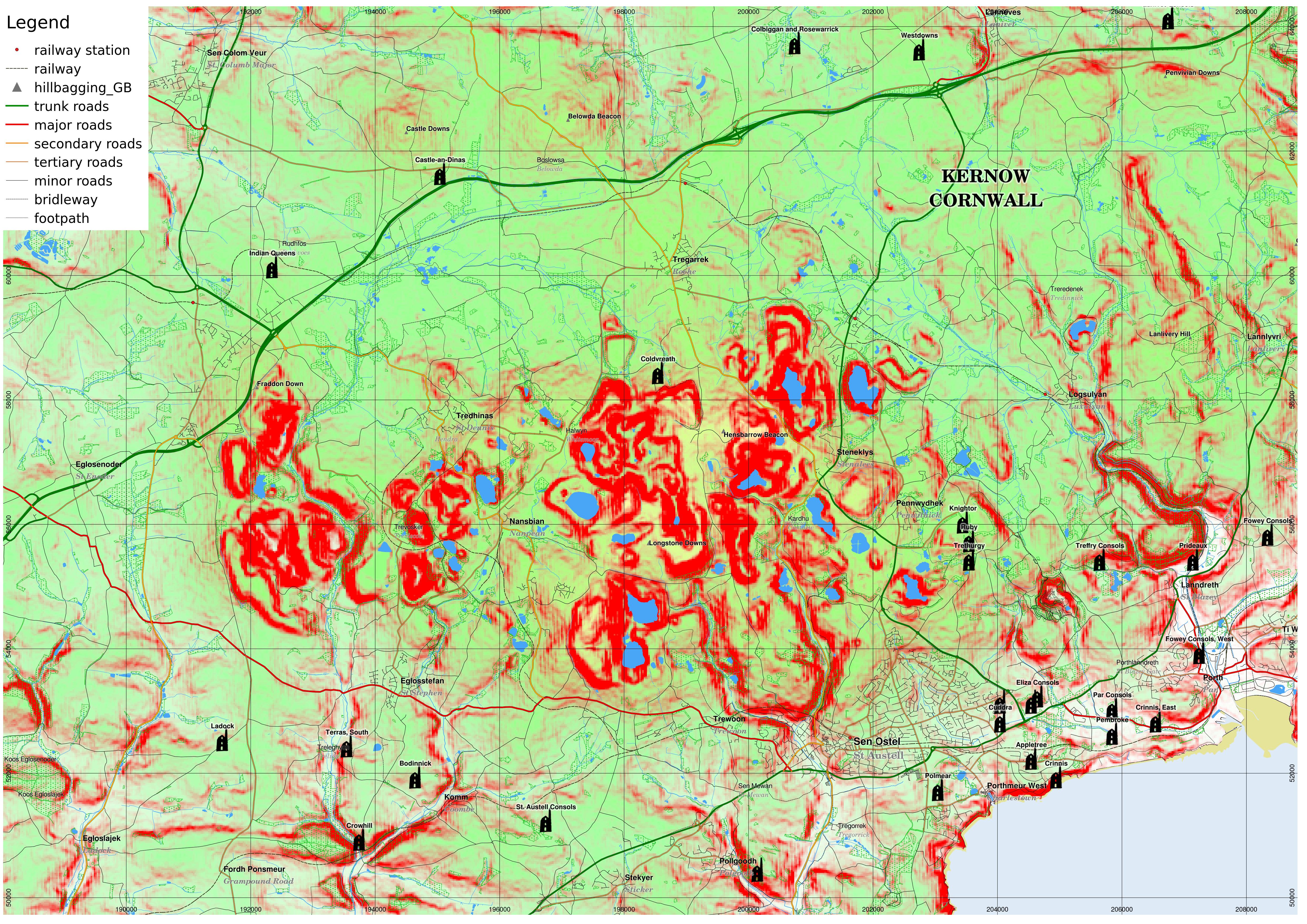
One particular topic that I thought I could shed some light on with my work on maps was Ken Mackinnon's "Henderson’s Black-more revisited: disinterring a lost landscape" which discussed the Cornish language in the china clay (kaolin) mining area of mid-Cornwall, in which the landscape itself has been altered and some of the older history obscured by the activities of the industry.
For instance, a stone called "Men Vagar" originally stood at Longstone Downs but was moved to Roche when the original site was covered by a china clay spoil heap.
Ken's presentation also said that the Cornish language had been spoken in the area until the late 17th century, which was later than I had thought.
I have reproduced an extract from my own topographic maps, with names in Cornish from MAGA, and topography from the Shuttle Radar Topography Mission, and with the slope lines method that makes use of the segmentation method developed for my MSc thesis on Martian glaciology!
I also add the mines that I detailed from various sources on my website.
The elevation I show with colour shading.
Land at sea level is white, which becomes more green up to 250m. I also overlay yellow at higher elevations from 100m up to 350m.
I also have a number of hills marked from the database from www.hill-bagging.co.uk.
I overlay various vector data including roads from OpenStreetMap and foreshore, and inland water from OS Opendata layers.
The conference had a number of presentations on a range of topics about the language, ranging from grammatical topics, the various manuscript sources of Cornish, to translating Cornish poetry into Italian.
One particular topic that I thought I could shed some light on with my work on maps was Ken Mackinnon's "Henderson’s Black-more revisited: disinterring a lost landscape" which discussed the Cornish language in the china clay (kaolin) mining area of mid-Cornwall, in which the landscape itself has been altered and some of the older history obscured by the activities of the industry.
For instance, a stone called "Men Vagar" originally stood at Longstone Downs but was moved to Roche when the original site was covered by a china clay spoil heap.
Ken's presentation also said that the Cornish language had been spoken in the area until the late 17th century, which was later than I had thought.
I have reproduced an extract from my own topographic maps, with names in Cornish from MAGA, and topography from the Shuttle Radar Topography Mission, and with the slope lines method that makes use of the segmentation method developed for my MSc thesis on Martian glaciology!
I also add the mines that I detailed from various sources on my website.
The elevation I show with colour shading.
Land at sea level is white, which becomes more green up to 250m. I also overlay yellow at higher elevations from 100m up to 350m.
I also have a number of hills marked from the database from www.hill-bagging.co.uk.
I overlay various vector data including roads from OpenStreetMap and foreshore, and inland water from OS Opendata layers.
 |
| In this version, I show slope with the red channel, overlaid with slopes of 15 degrees or over solid red. large version |
 |
| This version shows slope direction using the segmented digital elevation model (based on the method used in my Martian glaciology thesis). I visualise it in the way I did in some earlier blog posts, where the steeper the slope, the thicker the lines. Concave slopes are blue, convex are red, and they are black if they are planar. larger version |
 |
| Same as above, but with a different elevation colour-coding which perhaps makes it easier to see what the actual elevation is, but maybe harder to distinguish the slope lines. larger version |
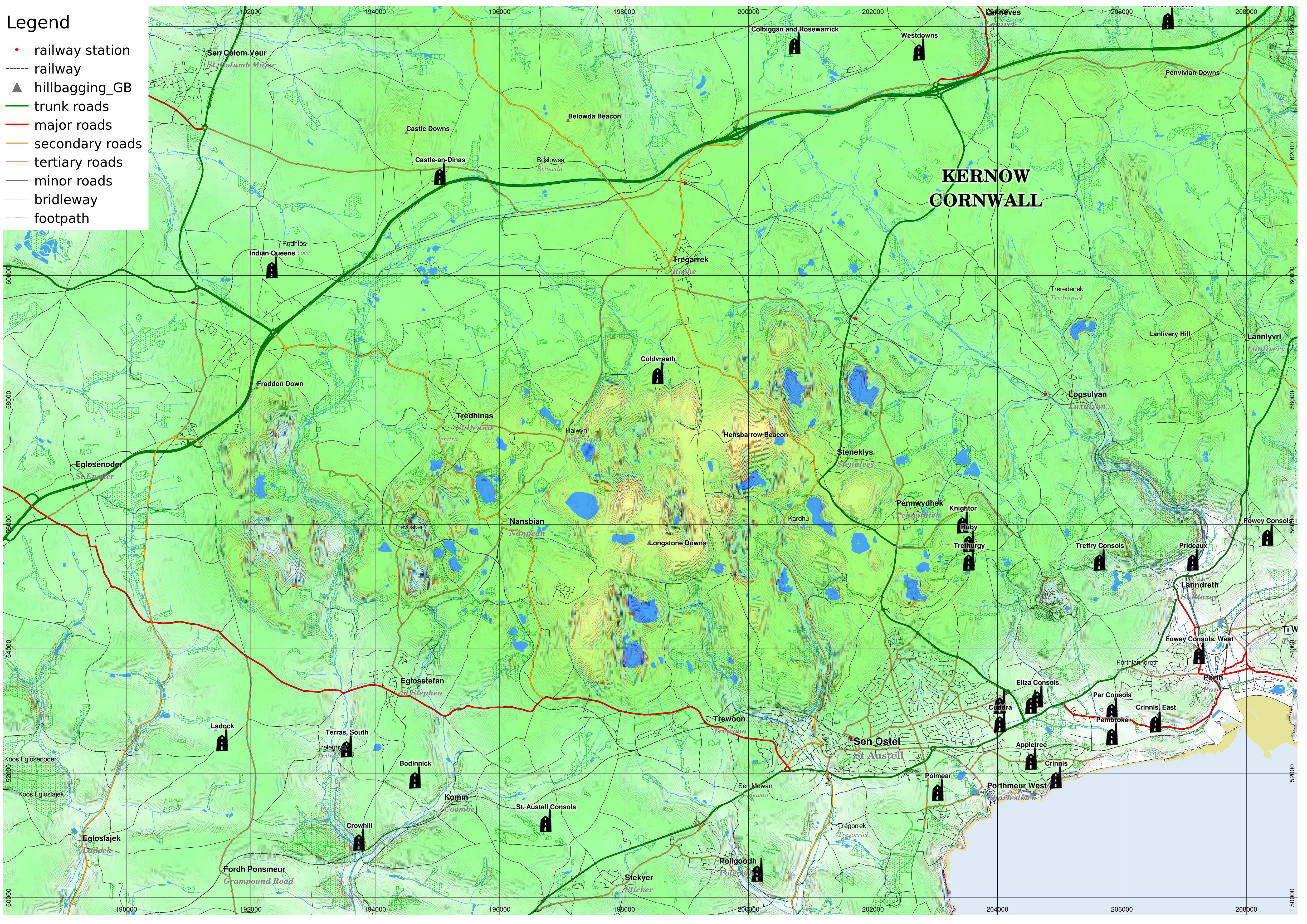
Edit - OpenStreetMap landuse:'quarry'
 |
| In the landuse layer of OpenStreetMap, the 'quarry' type captures most (but not quite all) of the artificial land surfaces due to kaolin quarrying. larger version |
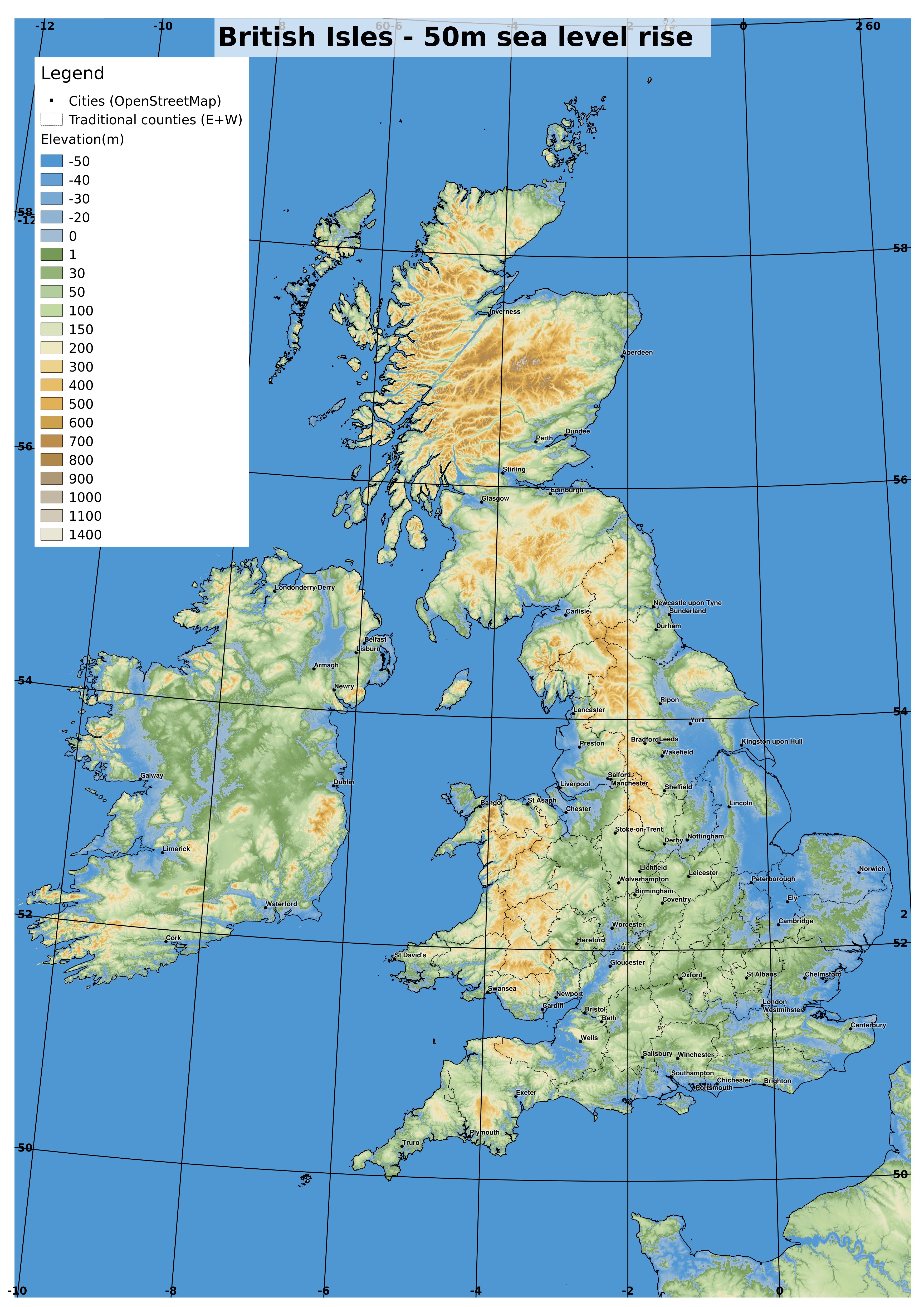
The Meriga Project - British Isles
Since I have the 1 arcsec SRTM data ready to go for the British Isles, I thought I'd make a more detailed map for the Meriga Project shared-world speculative fiction anthology for the British Isles. See my last post for an explanation.
 |
| OS grid ref projection. 1:3million if printed at A3. full-size version |
 |
| OS grid ref projection. 1:1.5million if printed at A3. full-size version |
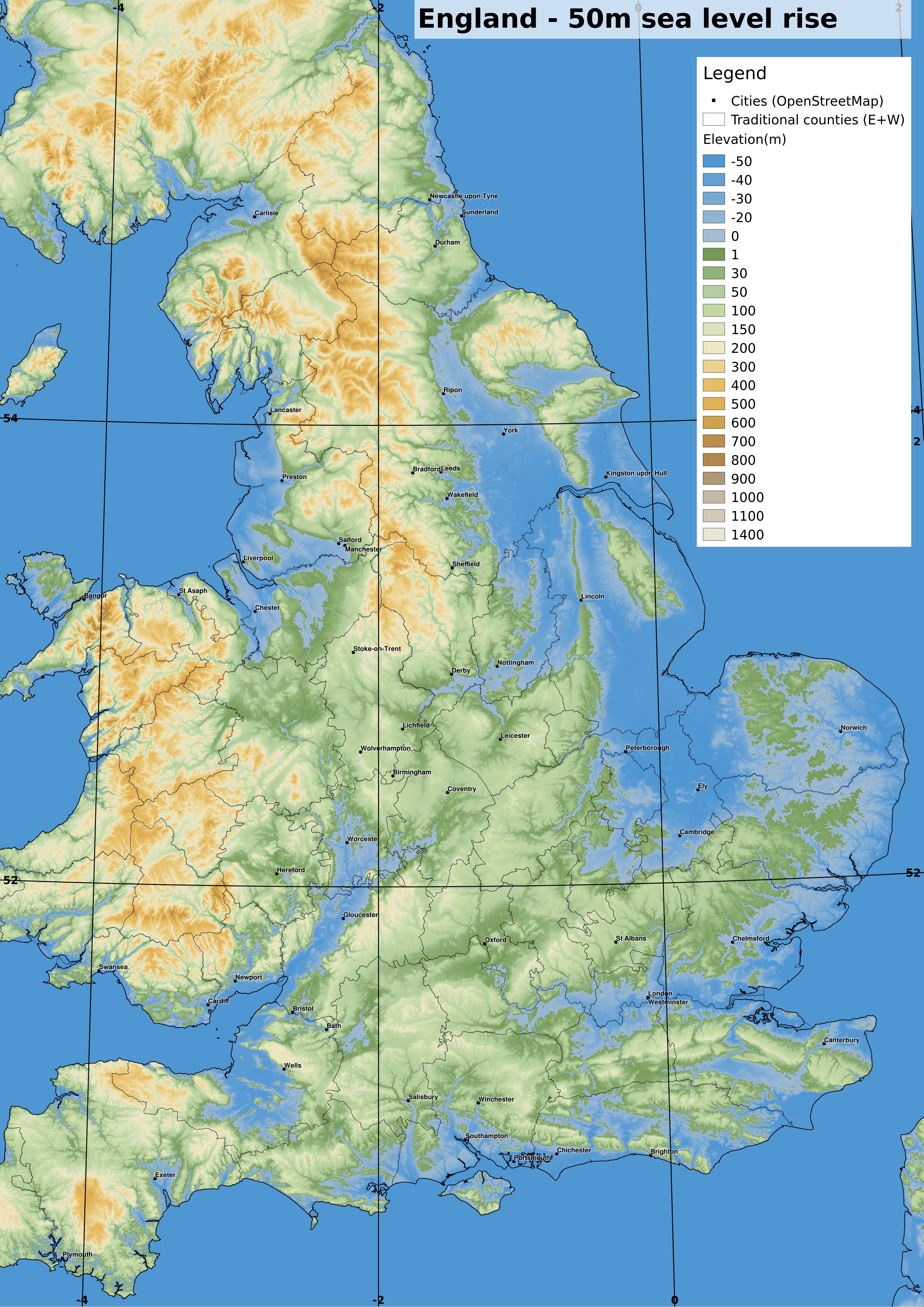
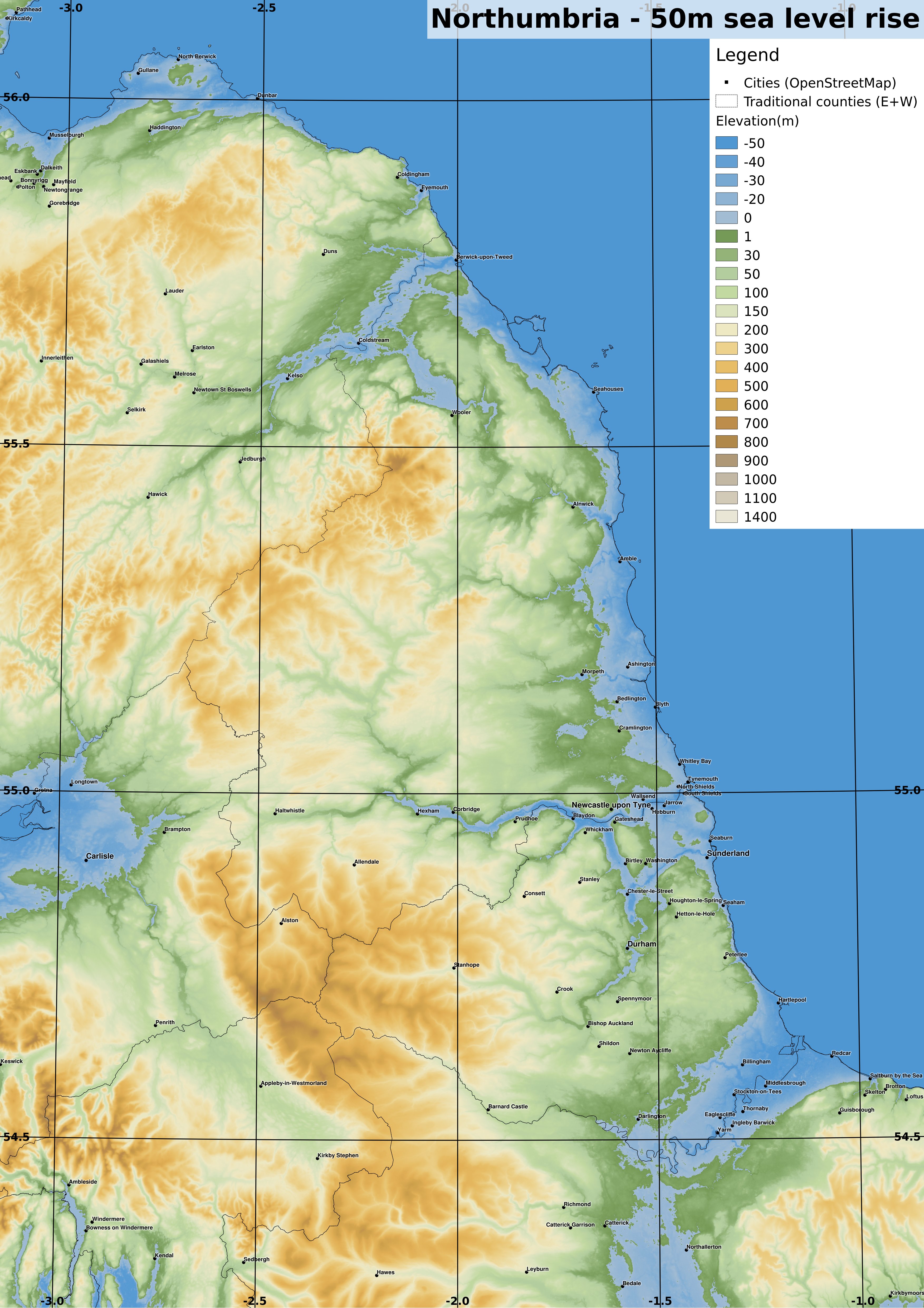
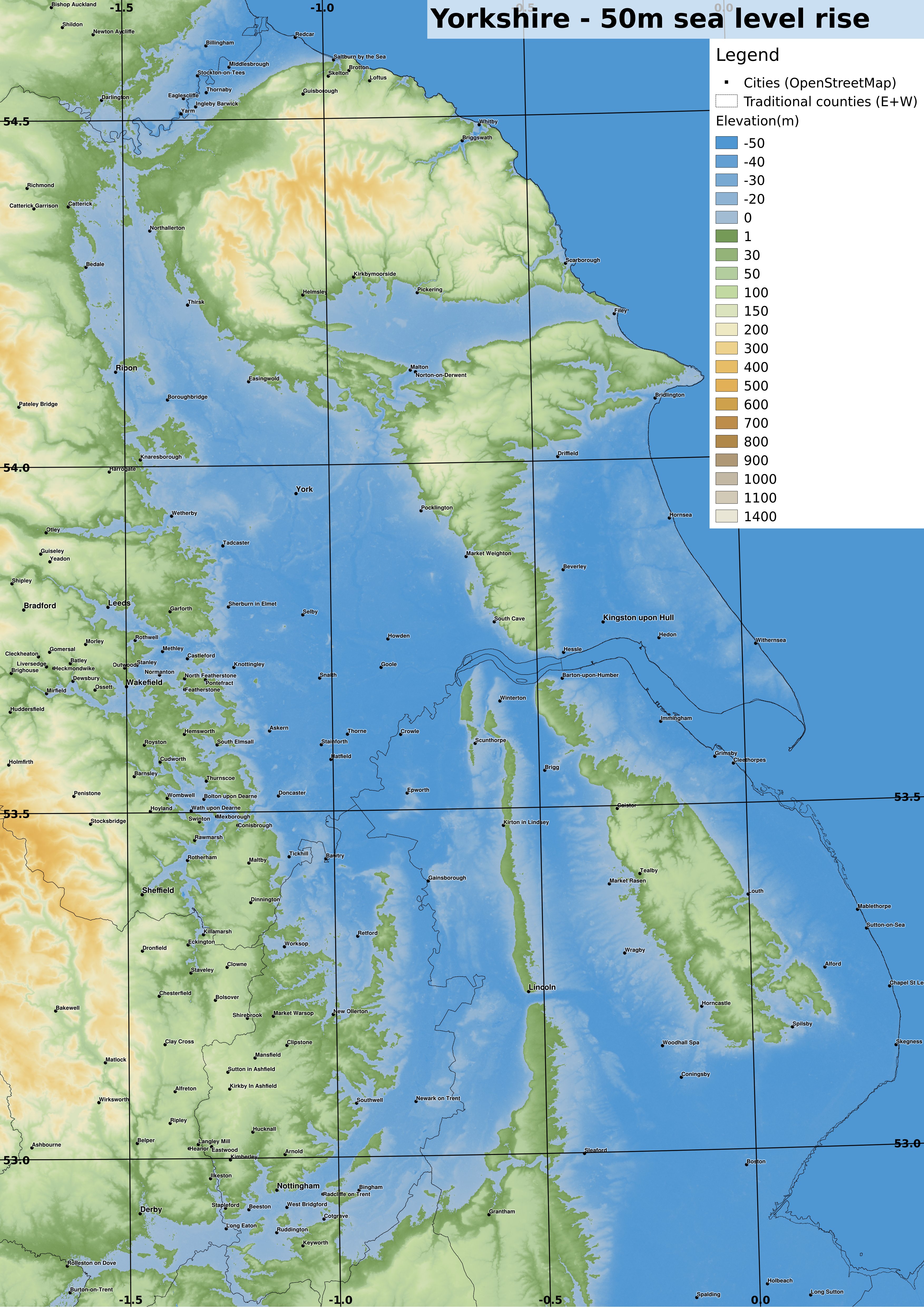
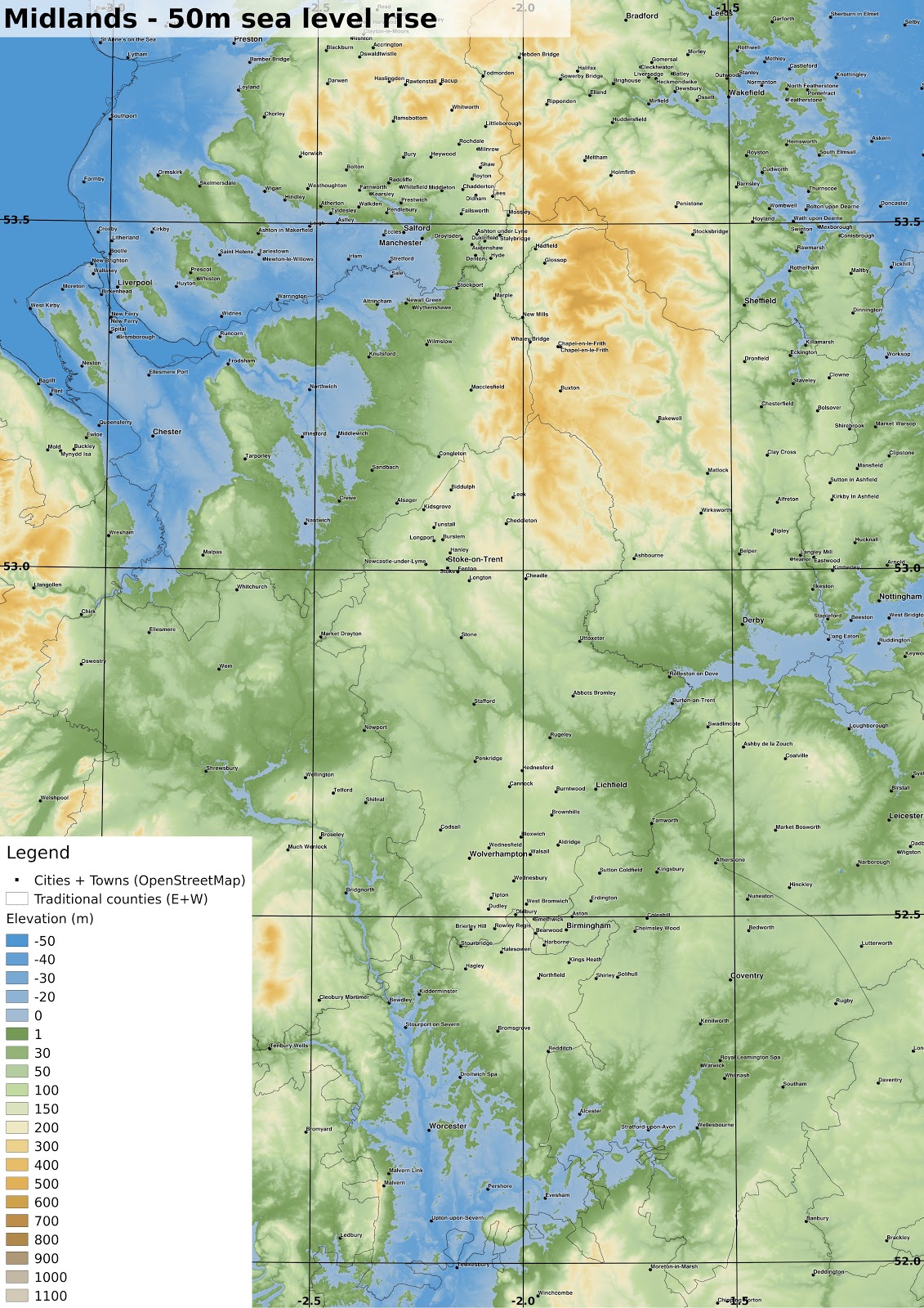
Some more detailed maps
I have rendered some more detailed maps at a scale of 1:500000 at A3, of certain areas, which should now cover most of England and Wales, though I have not yet done Scotland and Ireland. |
| OS grid ref projection. 1:500000 if printed at A3. The England-Scotland border now has a substantial inlet along the Tweed. The Tyne also reaches far inland. full-size version |
 |
| OS grid ref projection. 1:500000 if printed at A3. Substantial flooding in the Vale of York results in the North York Moors now being an island, with other islands forming the remnants of Lincolnshire. full-size version |
 |
| OS grid ref projection. 1:500000 if printed at A3. The overland routes linking the expanded seas are now rather shortened. full-size version |
 |
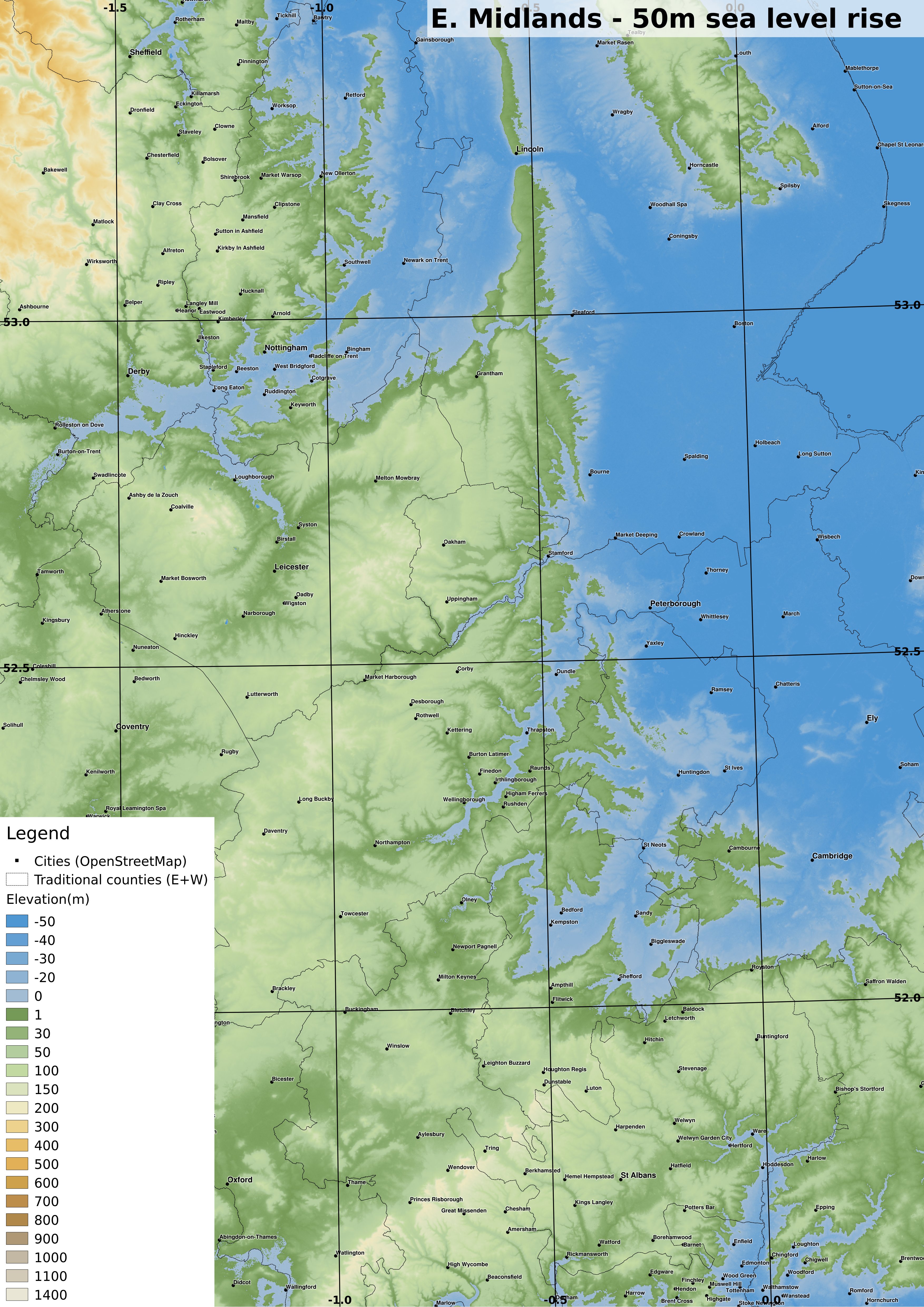
| OS grid ref projection. 1:500000 if printed at A3. Nottingham, Derby and Loughborough are now seaside towns. full-size version |
 |
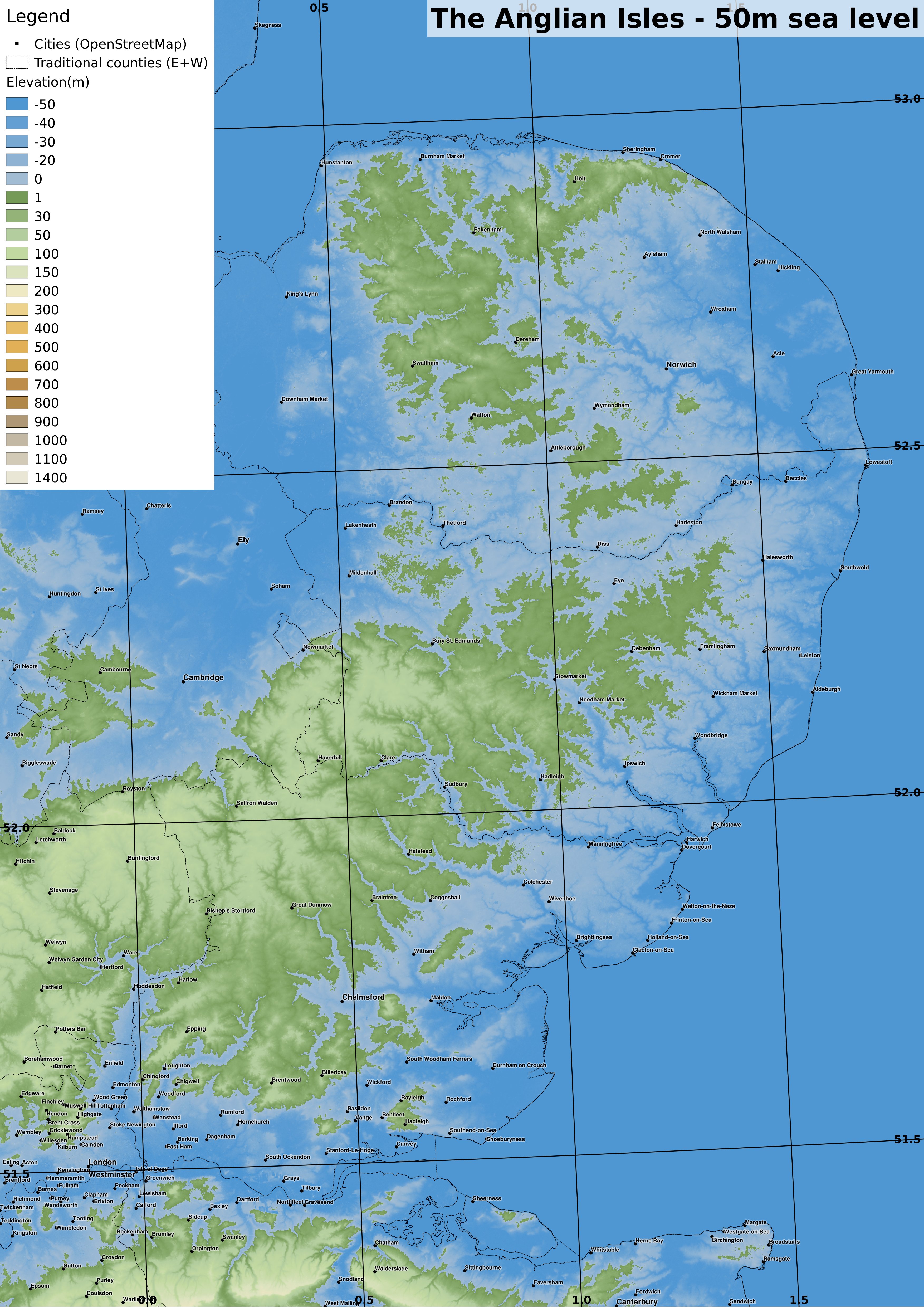
| OS grid ref projection. 1:500000 if printed at A3. The Anglian Isles are inhabited by people making the most of the declining land area. full-size version |
 |
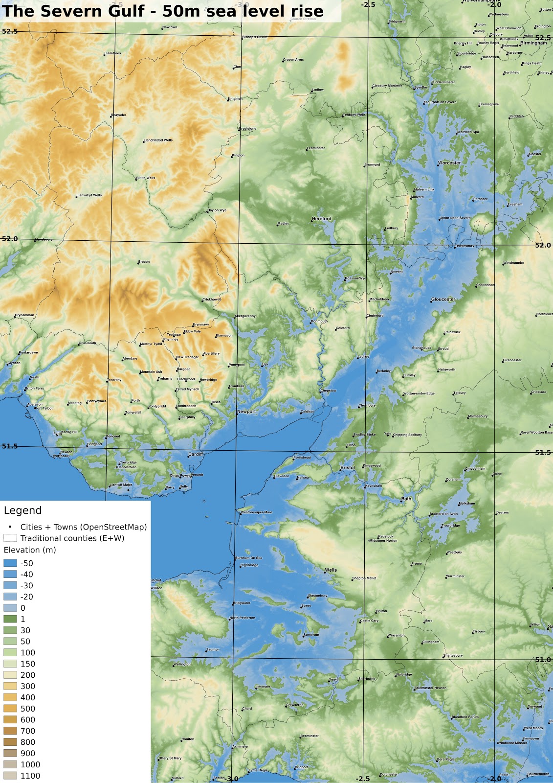
| OS grid ref projection. 1:500000 if printed at A3. Perhaps central London was drowned catastrophically after the Thames Barrier (or its successor) failed. The technological limitations of this age make underwater salvage risky, but rewarding... full-size version |
 |
| OS grid ref projection. 1:500000 if printed at A3. full-size version |
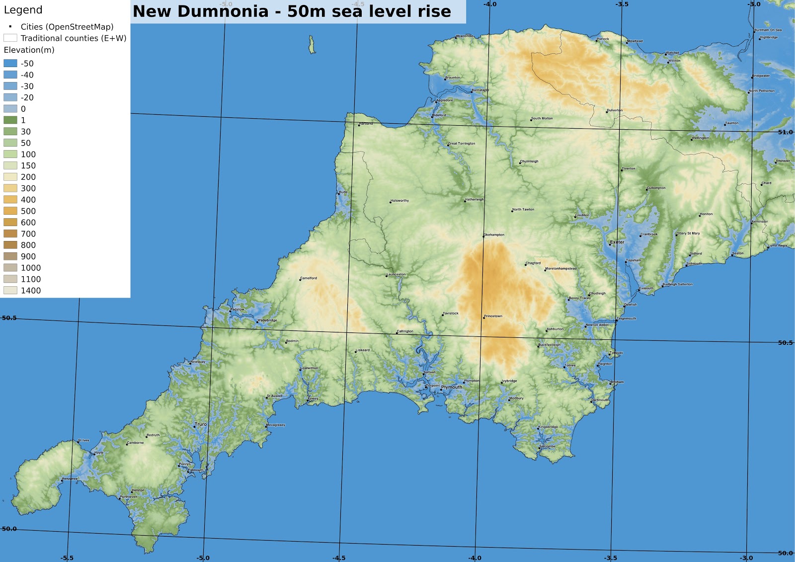 |
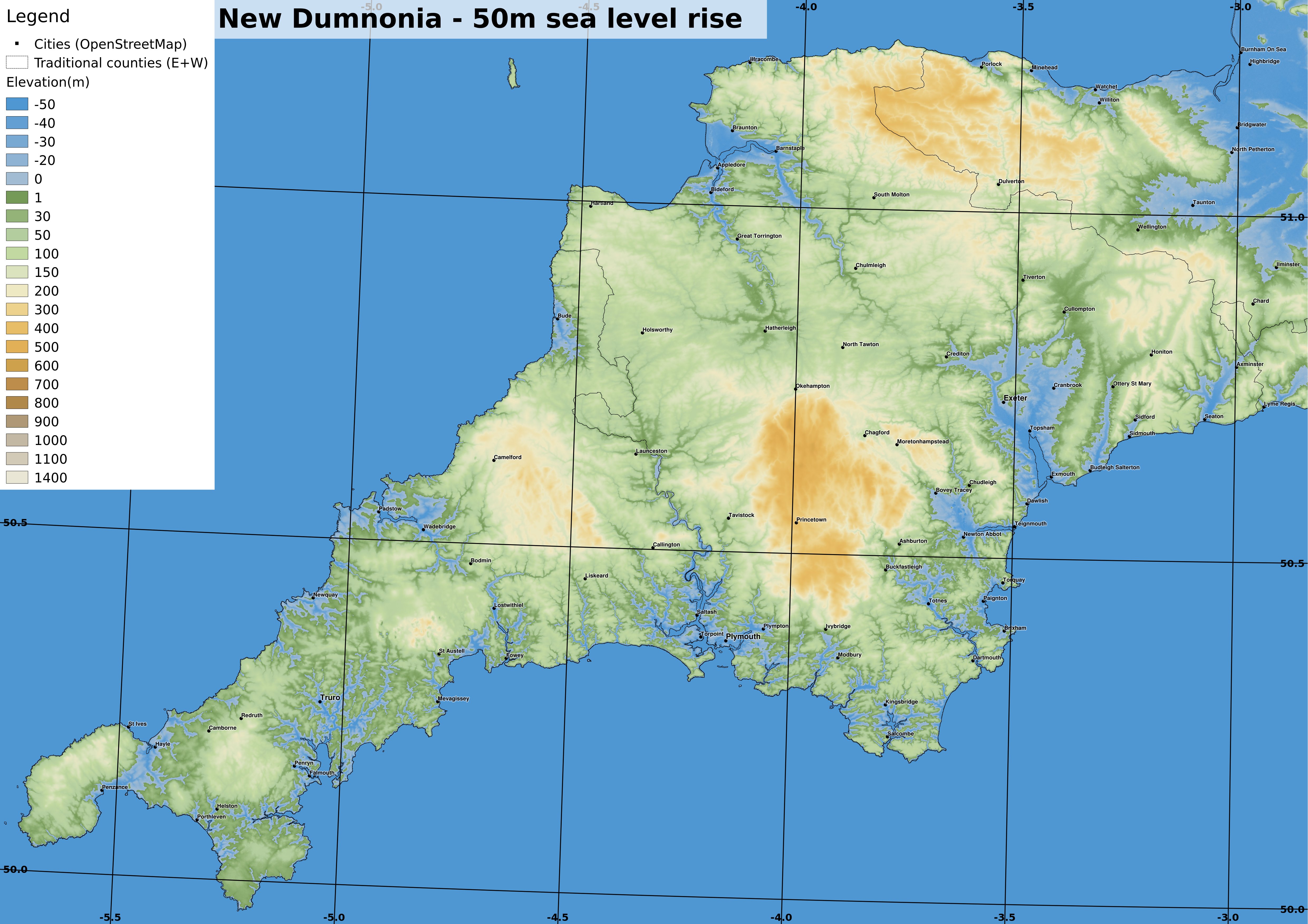
| OS grid ref projection. 1:500000 if printed at A3. Devon and Cornwall now have a much thinner connection to the 'mainland' after the Somerset Levels and the Exe valley sank under the rising seas. Cornwall has a maze of drowned river valleys and is inhabited by two distinct cultural groups, firstly semi-nomadic people travelling in small boats and secondly the upland agricultural settlements. West Penwith is now an island separated by a strait since sea levels were 30m above the pre-industrial level. full-size version |
 |
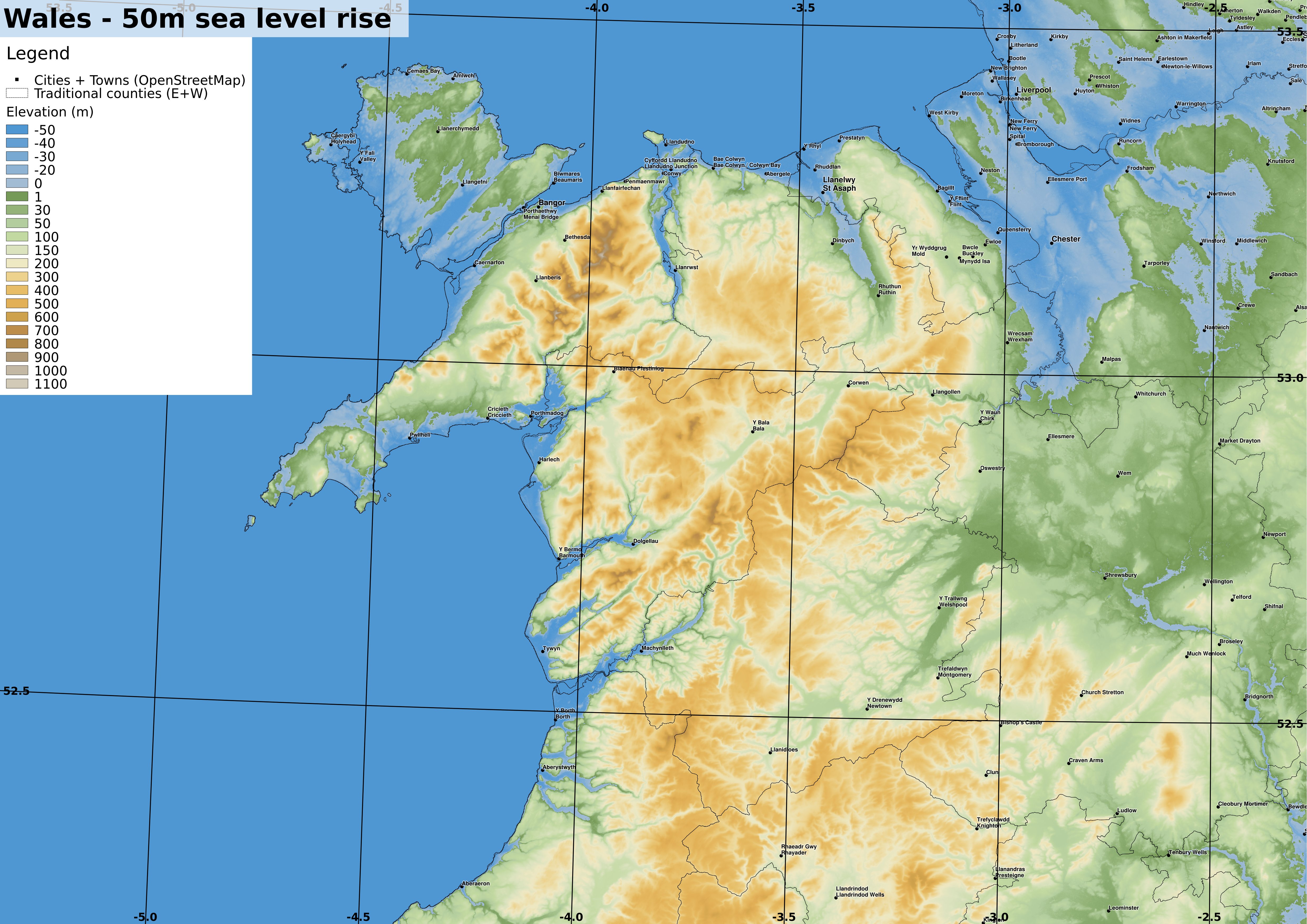
| OS grid ref projection. 1:500000 if printed at A3. Wales is now more deeply incised by river estuaries, with much of Anglesey underwater. full-size version |
 |
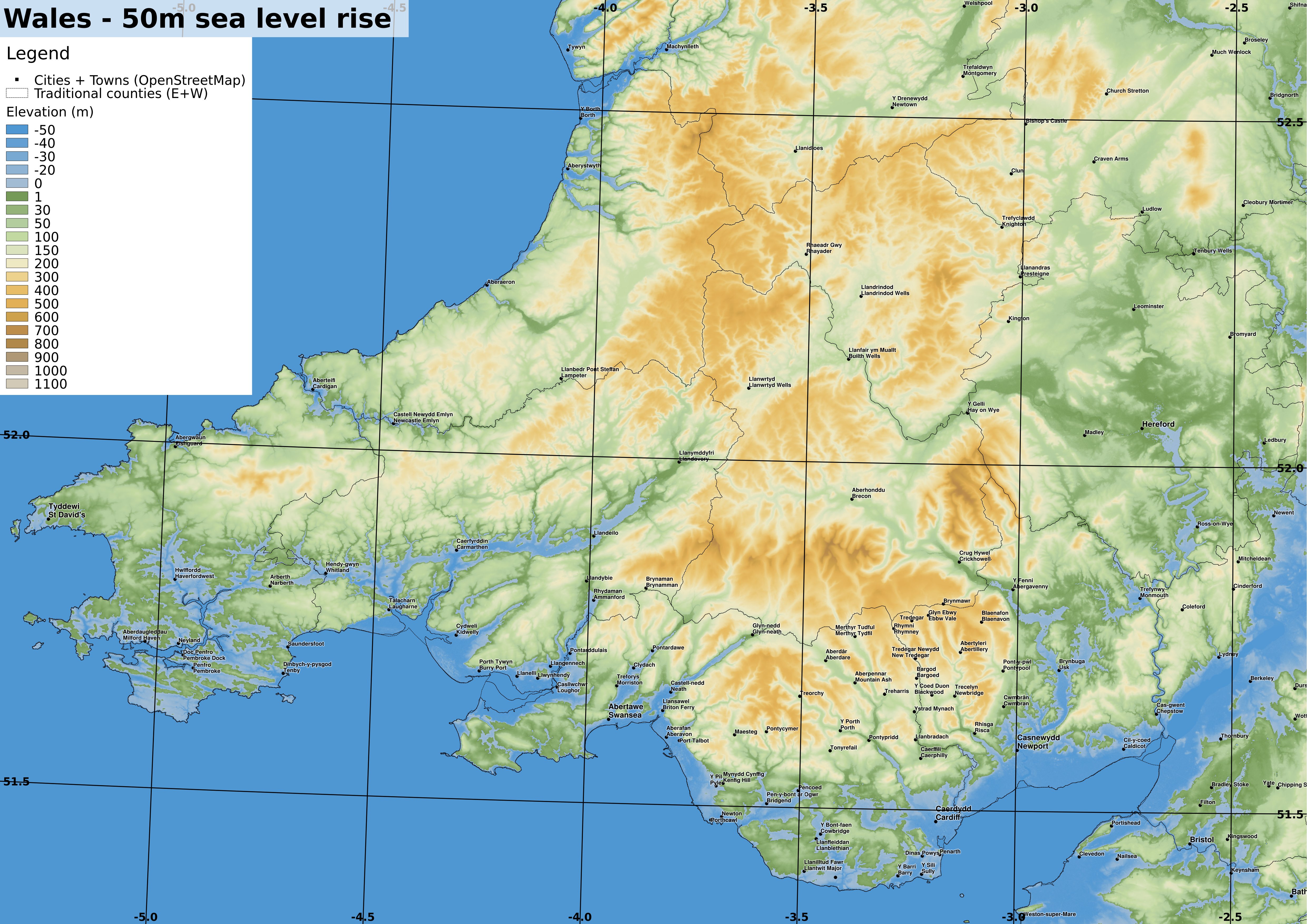
| OS grid ref projection. 1:500000 if printed at A3. Similarly to the Cornish coast, some parts of Wales have a maze of islands and small river valleys inhabited by the nomadic boat people. full-size version |
« Prev
1
2
3
4
5
6
7
8
9
10
11
12
13
14
15
16
17
18
19
20
21
22
23
24
25
26
27
28
29
30
31
32
33
34
35
36
37
38
39
40
41
42
43
44
45
46
47
Next »