Skrifennow
My blog, imported from Blogger and converted using Jekyll.
Dec 1, 2016
In the
last post I noted the distribution of glacier-like forms according to elevation relative to Mars datum, and slope, as measured by the
Mars Express HRSC DTM data.
One issue is whether the distribution according to elevation is a primary function of elevation, or the fact that the distribution of slope varies according to elevation in the area of study.
The distribution of slope and elevation was considered previously:
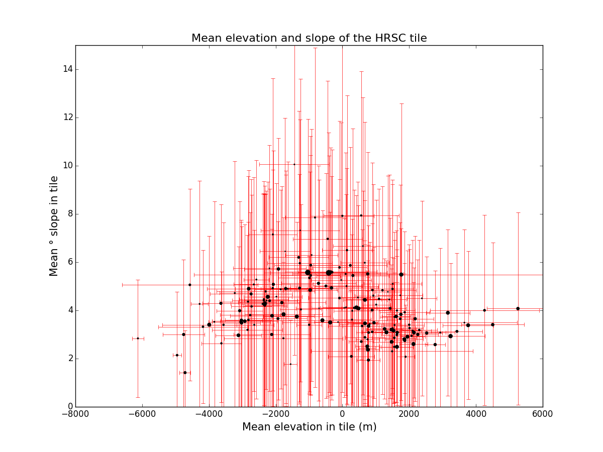
What will be needed however is the histogram of slope as a function of elevation. Below is a table of 179 HRSC DTM tiles that contain coverage of Souness objects, detailing mean, minimum and maximum elevation and slope, etc. A more comprehensive statistical assessment would use all HRSC DTM tiles that exist in the latitude range 25° - 70° that Souness studied.
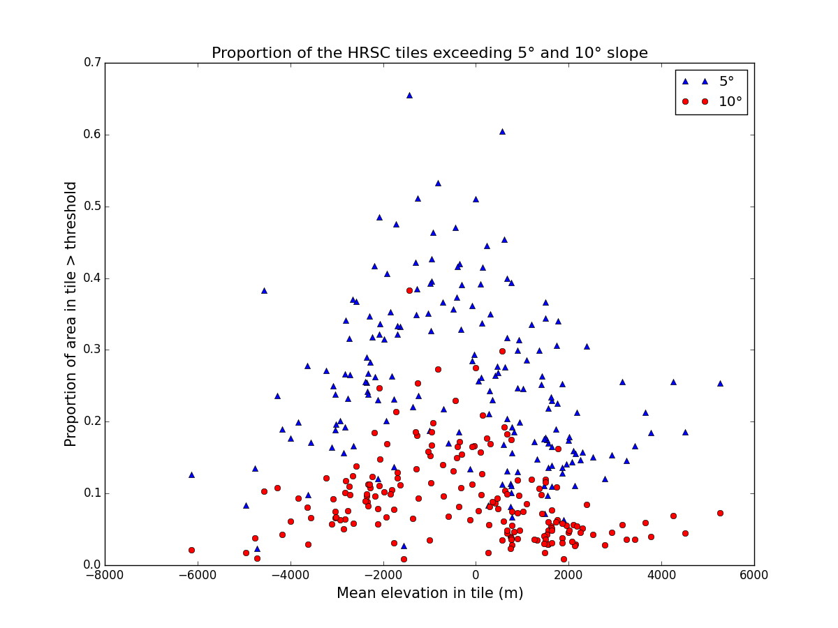
Here are a couple of plots, showing the mean slope as a function of mean elevation, with errorbars, and the area of the plotting symbol proportional to the area of each tile, and a plot showing the proportion of each tile having slope exceeding 5° and 10° respectively.
Table of HRSC tiles
For comparison, the area of the UK is 243600km
2. Several individual tiles are larger than this, the largest being h0533. The average area of each tile is
87055km2. Total area, ignoring overlap is 15.6 million km
2, and taking account of overlap, it is
13.4 million km2. To find more about an individual tile, click on the link in the first column to the tile's page on
Arizona State University's Mars Image Explorer or using
HRSCview.
| Field | Dimensions | DTM Resolution | Centre location | Area | Mean elev | Min elev | Max elev | Average slope | Percentage exceeding 10° |
|---|
| h0022_0000 | (12781, 1173) px | 100m | 100.9°E, 29.4°S | 98445km2 | 314.1 | -2356 | 4399 | 5.4° | 16.9% |
| h0037_0000 | (36203, 4729) px | 50m | 131.9°W, 29.4°N | 217870km2 | 1762.4 | -2722 | 21234 | 5.5° | 16.3% |
| h0248_0000 | (6562, 1216) px | 50m | 102.6°E, 37.2°S | 18548km2 | 110.1 | -816 | 3358 | 4.1° | 9.8% |
| h0266_0000 | (6715, 1463) px | 50m | 94.7°W, 43.3°S | 18355km2 | 3653.4 | 2002 | 8427 | 3.5° | 6.0% |
| h0280_0000 | (8361, 1039) px | 75m | 153.6°E, 39.9°S | 34376km2 | 754.2 | -52 | 1842 | 2.8° | 3.8% |
| h0365_0000 | (10801, 1685) px | 75m | 90.7°E, 45.5°S | 56958km2 | -4177.5 | -5841 | -459 | 3.3° | 4.3% |
| h0368_0000 | (12191, 1663) px | 75m | 118.3°E, 41.9°S | 67909km2 | 783.8 | -728 | 2808 | 3.1° | 5.5% |
| h0376_0000 | (13048, 2782) px | 50m | 29.1°W, 48.7°S | 46781km2 | -346.6 | -3392 | 3730 | 5.6° | 17.2% |
| h0383_0000 | (1601, 1068) px | 75m | 37.9°W, 43.1°S | 8767km2 | -1715.5 | -4305 | 1025 | 6.4° | 21.4% |
| h0394_0000 | (7360, 1523) px | 75m | 52.0°W, 42.4°S | 42870km2 | 561.4 | -1847 | 3741 | 7.9° | 29.9% |
| h0397_0000 | (22832, 2260) px | 75m | 13.0°E, 37.1°S | 146656km2 | 1612.3 | -143 | 2981 | 3.7° | 5.4% |
| h0416_0000 | (8537, 1457) px | 100m | 55.2°W, 46.6°S | 73480km2 | 236.5 | -2513 | 3608 | 5.9° | 17.7% |
| h0424_0000 | (10549, 2394) px | 50m | 121.4°W, 44.3°S | 45403km2 | 2071.6 | 588 | 3526 | 2.9° | 3.4% |
| h0427_0000 | (8101, 2100) px | 75m | 57.1°W, 44.0°S | 53877km2 | 1200.5 | -1230 | 3735 | 4.8° | 12.0% |
| h0451_0000 | (6222, 2598) px | 100m | 103.2°E, 38.8°S | 70761km2 | -87.0 | -2557 | 4692 | 4.5° | 11.3% |
| h0453_0000 | (10385, 1838) px | 75m | 92.0°W, 41.2°S | 79320km2 | 4257.2 | 650 | 8978 | 4.0° | 6.9% |
| h0466_0000 | (6081, 1339) px | 150m | 69.7°E, 20.8°S | 145309km2 | -327.9 | -4469 | 3638 | 4.9° | 10.7% |
| h0469_0000 | (7227, 2011) px | 75m | 135.0°E, 40.5°S | 63422km2 | 1630.0 | -581 | 2786 | 3.0° | 5.1% |
| h0478_0000 | (18069, 2865) px | 125m | 30.2°W, 23.6°S | 410550km2 | -1037.0 | -4661 | 2167 | 5.6° | 15.8% |
| h0479_0000 | (3458, 1348) px | 100m | 128.1°W, 42.7°S | 40474km2 | 2102.0 | 515 | 4837 | 3.2° | 5.6% |
| h0497_0000 | (10101, 1885) px | 100m | 97.0°W, 37.0°S | 135551km2 | 4503.0 | 1828 | 7379 | 3.4° | 4.5% |
| h0506_0000 | (11762, 1920) px | 125m | 98.3°E, 33.1°S | 221775km2 | -367.1 | -3175 | 5458 | 3.5° | 8.1% |
| h0508_0000 | (12599, 2646) px | 75m | 98.8°W, 34.0°S | 138944km2 | 5258.3 | 2429 | 9155 | 4.1° | 7.3% |
| h0528_0000 | (11402, 2553) px | 100m | 93.1°E, 29.6°S | 208685km2 | -599.9 | -5230 | 3696 | 3.6° | 6.8% |
| h0533_0000 | (13073, 2294) px | 150m | 38.2°W, 22.0°S | 456221km2 | -409.1 | -5430 | 2640 | 5.6° | 15.0% |
| h0544_0000 | (2790, 1207) px | 150m | 37.9°W, 40.6°S | 66060km2 | -985.3 | -4288 | 2220 | 5.3° | 15.2% |
| h0550_0000 | (4445, 1789) px | 125m | 92.3°E, 32.5°S | 111078km2 | -2117.2 | -5390 | 1221 | 3.0° | 5.8% |
| h0558_0000 | (6320, 2251) px | 125m | 25.5°E, 32.1°S | 174245km2 | 1948.4 | -161 | 3562 | 2.9° | 5.5% |
| h0988_0000 | (14122, 1433) px | 75m | 77.2°E, 22.5°N | 83411km2 | -1307.1 | -3523 | 1505 | 6.2° | 18.5% |
| h1201_0000 | (5202, 1373) px | 75m | 24.6°E, 43.5°N | 28478km2 | -3224.1 | -3909 | -1732 | 4.7° | 12.1% |
| h1210_0000 | (2491, 931) px | 75m | 138.1°W, 39.0°N | 12230km2 | -1629.8 | -3168 | 179 | 4.9° | 11.2% |
| h1232_0000 | (3912, 1097) px | 75m | 140.3°W, 37.4°N | 17785km2 | -1977.9 | -3581 | -5 | 4.6° | 10.2% |
| h1241_0000 | (4672, 1362) px | 75m | 54.2°E, 44.6°N | 24804km2 | -2578.1 | -3295 | -183 | 5.3° | 13.8% |
| h1258_0000 | (5101, 1072) px | 75m | 177.6°W, 32.5°N | 22915km2 | -3837.0 | -4161 | -2610 | 3.5° | 9.3% |
| h1312_0000 | (7271, 1337) px | 75m | 84.7°W, 35.8°N | 36762km2 | 926.3 | -1001 | 2700 | 4.6° | 9.7% |
| h1316_0000 | (5401, 1233) px | 100m | 119.7°W, 31.7°N | 40045km2 | 1893.0 | 663 | 2821 | 2.1° | 0.9% |
| h1317_0000 | (4001, 886) px | 100m | 144.6°E, 31.7°N | 28788km2 | -1767.1 | -4681 | 1680 | 2.8° | 3.1% |
| h1351_0000 | (8402, 1977) px | 75m | 41.0°E, 47.4°N | 48721km2 | -2762.2 | -4659 | 978 | 3.8° | 7.6% |
| h1391_0000 | (12890, 1476) px | 100m | 68.3°E, 37.3°N | 120274km2 | -1699.3 | -5080 | 1573 | 4.9° | 12.9% |
| h1395_0000 | (5203, 1512) px | 100m | 34.7°E, 43.5°N | 44511km2 | -2828.2 | -4259 | -698 | 4.4° | 10.1% |
| h1412_0000 | (11403, 1941) px | 100m | 165.0°E, 41.4°N | 113313km2 | -3078.8 | -4178 | 487 | 4.0° | 9.3% |
| h1423_0000 | (15994, 2143) px | 75m | 163.3°E, 39.5°N | 127585km2 | -3021.1 | -4072 | 283 | 3.5° | 6.7% |
| h1428_0000 | (13002, 3085) px | 75m | 30.3°E, 42.3°N | 102455km2 | -2734.8 | -7153 | 165 | 4.7° | 11.0% |
| h1429_0000 | (20803, 3289) px | 75m | 67.5°W, 39.2°N | 171804km2 | -966.9 | -3765 | 1326 | 4.8° | 11.5% |
| h1446_0000 | (11318, 2014) px | 100m | 60.8°E, 38.4°N | 133749km2 | -1916.4 | -3797 | 767 | 5.7° | 16.9% |
| h1450_0000 | (18203, 4148) px | 75m | 27.8°E, 41.8°N | 163141km2 | -2807.8 | -7127 | -169 | 4.9° | 11.8% |
| h1461_0000 | (16986, 4749) px | 75m | 25.4°E, 43.9°N | 154244km2 | -2924.2 | -6588 | -492 | 3.6° | 6.3% |
| h1468_0000 | (19462, 3367) px | 75m | 58.6°E, 47.6°N | 169273km2 | -3114.9 | -5556 | -38 | 3.0° | 5.7% |
| h1483_0000 | (11102, 3084) px | 100m | 23.5°E, 42.8°N | 143811km2 | -3036.0 | -4265 | -671 | 3.5° | 6.6% |
| h1498_0000 | (7603, 2119) px | 100m | 11.6°W, 34.3°N | 110710km2 | -3640.2 | -5207 | -2165 | 4.3° | 8.1% |
| h1523_0000 | (10543, 3418) px | 75m | 49.8°E, 43.1°N | 116809km2 | -1814.8 | -3636 | 914 | 4.3° | 10.5% |
| h1526_0000 | (5503, 2821) px | 75m | 115.0°E, 40.1°N | 63553km2 | -4952.7 | -6556 | -4301 | 2.1° | 1.7% |
| h1528_0000 | (16803, 3537) px | 75m | 80.5°W, 40.3°N | 196042km2 | 480.7 | -2965 | 2791 | 4.1° | 7.9% |
| h1545_0000 | (9373, 3847) px | 75m | 46.5°E, 44.1°N | 113871km2 | -2069.4 | -4212 | 664 | 5.1° | 14.8% |
| h1550_0000 | (16403, 3782) px | 75m | 83.5°W, 41.0°N | 208952km2 | 419.0 | -2573 | 3222 | 4.1° | 8.6% |
| h1578_0000 | (8602, 3013) px | 100m | 43.0°E, 44.1°N | 160965km2 | -2107.2 | -4483 | 1032 | 3.8° | 7.9% |
| h1600_0000 | (7501, 2721) px | 125m | 38.6°E, 39.7°N | 199966km2 | -1366.3 | -3900 | 972 | 3.7° | 6.5% |
| h1607_0000 | (5002, 2045) px | 175m | 71.4°E, 38.0°N | 226517km2 | -2320.6 | -4132 | 889 | 4.3° | 11.3% |
| h1628_0000 | (5002, 3727) px | 100m | 165.4°E, 40.9°N | 138771km2 | -3025.3 | -4670 | 455 | 3.6° | 7.5% |
| h1629_0000 | (5302, 2471) px | 150m | 63.3°E, 38.9°N | 215818km2 | -2235.9 | -4490 | 12 | 4.6° | 12.3% |
| h1644_0000 | (1952, 1607) px | 175m | 33.7°E, 40.4°N | 86440km2 | -1930.3 | -3762 | 541 | 3.7° | 6.7% |
| h1887_0000 | (2502, 1418) px | 250m | 108.5°E, 41.6°S | 171008km2 | 675.1 | -920 | 4429 | 4.4° | 10.0% |
| h1932_0000 | (4227, 1298) px | 225m | 6.4°E, 40.5°S | 206200km2 | 1318.3 | -1607 | 2720 | 3.1° | 3.5% |
| h1937_0000 | (9003, 1817) px | 100m | 125.1°W, 30.9°S | 125929km2 | 2777.4 | 1115 | 4173 | 2.6° | 2.8% |
| h2159_0000 | (4012, 1367) px | 75m | 19.6°E, 45.6°S | 26129km2 | 1506.1 | 394 | 3048 | 3.3° | 3.6% |
| h2181_0000 | (4804, 1207) px | 100m | 17.4°E, 48.3°S | 43588km2 | 1551.6 | 702 | 2841 | 2.5° | 2.9% |
| h2195_0000 | (3952, 993) px | 100m | 82.8°E, 45.1°S | 31518km2 | -6126.6 | -7179 | -5386 | 2.8° | 2.1% |
| h2197_0000 | (2011, 1302) px | 100m | 114.0°W, 52.0°S | 19989km2 | 1505.8 | -354 | 3428 | 5.1° | 11.9% |
| h2210_0000 | (1502, 1067) px | 100m | 47.2°E, 48.3°S | 12625km2 | -2184.6 | -4542 | 1064 | 5.7° | 18.5% |
| h2220_0000 | (5682, 2373) px | 75m | 144.4°E, 48.1°S | 34383km2 | 1560.7 | -115 | 3208 | 3.7° | 6.0% |
| h2224_0000 | (6432, 1196) px | 75m | 112.9°E, 41.3°S | 27821km2 | 632.7 | -1484 | 3716 | 4.5° | 10.4% |
| h2247_0000 | (8833, 2025) px | 75m | 12.3°E, 53.5°S | 58270km2 | 1553.7 | -135 | 2780 | 2.9° | 2.9% |
| h2279_0000 | (8393, 1550) px | 50m | 108.5°E, 41.5°S | 24411km2 | 670.6 | -344 | 4319 | 6.0° | 18.2% |
| h2287_0000 | (11802, 3213) px | 75m | 41.7°E, 55.2°S | 77249km2 | 267.2 | -1113 | 2002 | 2.1° | 1.7% |
| h2312_0000 | (6001, 1723) px | 75m | 106.7°E, 43.4°S | 27029km2 | 286.2 | -399 | 2342 | 3.6° | 5.6% |
| h2345_0000 | (2401, 1116) px | 75m | 104.5°E, 45.1°S | 11286km2 | -130.5 | -1256 | 4619 | 3.5° | 6.3% |
| h2356_0000 | (2802, 974) px | 75m | 103.6°E, 40.5°S | 13506km2 | -34.6 | -1685 | 4701 | 5.3° | 16.6% |
| h2359_0000 | (2832, 1177) px | 75m | 169.2°E, 45.8°S | 13662km2 | 1732.5 | 173 | 3211 | 4.6° | 10.9% |
| h2386_0000 | (13002, 2303) px | 75m | 36.8°E, 50.3°S | 71588km2 | 564.7 | -1005 | 1530 | 2.7° | 3.5% |
| h2387_0000 | (10002, 1899) px | 75m | 61.0°W, 48.0°S | 54648km2 | 1497.9 | -656 | 3244 | 4.9° | 11.6% |
| h2400_0000 | (2613, 1613) px | 50m | 102.2°E, 40.5°S | 9657km2 | -699.9 | -2481 | 4063 | 4.1° | 9.6% |
| h2403_0000 | (8652, 1648) px | 75m | 167.8°E, 50.0°S | 50246km2 | 2010.5 | 495 | 3159 | 3.3° | 4.8% |
| h2430_0000 | (6606, 1747) px | 75m | 35.6°E, 52.1°S | 40109km2 | 739.1 | -735 | 1582 | 2.4° | 2.3% |
| h2438_0000 | (10043, 1416) px | 100m | 30.2°W, 45.4°S | 85303km2 | -494.9 | -3381 | 3358 | 5.0° | 13.2% |
| h2441_0000 | (13702, 2759) px | 75m | 33.8°E, 50.5°S | 87345km2 | 890.6 | -1284 | 2210 | 4.0° | 7.3% |
| h2460_0000 | (7274, 1464) px | 100m | 31.8°W, 47.6°S | 66541km2 | -952.4 | -3285 | 2447 | 5.5° | 16.7% |
| h2466_0000 | (3562, 1519) px | 100m | 98.9°E, 41.5°S | 35078km2 | -1243.3 | -2783 | 2617 | 4.0° | 9.4% |
| h2475_0000 | (5903, 1822) px | 75m | 65.2°W, 46.1°S | 43430km2 | 1863.8 | -423 | 3672 | 3.9° | 5.8% |
| h2493_0000 | (9635, 2247) px | 75m | 33.6°W, 49.3°S | 75915km2 | -950.4 | -2682 | 6113 | 5.9° | 18.6% |
| h2494_0000 | (15301, 2927) px | 75m | 131.8°W, 49.7°S | 121366km2 | 2181.4 | 303 | 4451 | 3.7° | 5.4% |
| h2501_0000 | (3501, 1770) px | 75m | 99.7°W, 47.8°S | 28233km2 | 2931.5 | 549 | 3878 | 3.1° | 4.5% |
| h2508_0000 | (15095, 3569) px | 100m | 67.7°W, 54.1°S | 171382km2 | 1469.5 | -868 | 3545 | 3.2° | 3.0% |
| h2510_0000 | (4885, 1230) px | 125m | 96.6°E, 40.5°S | 75220km2 | -2179.3 | -5436 | 3017 | 4.4° | 9.6% |
| h2515_0000 | (16219, 6793) px | 75m | 36.8°W, 62.6°S | 149827km2 | 783.7 | -2718 | 6143 | 3.4° | 7.5% |
| h2526_0000 | (6887, 1443) px | 125m | 35.4°W, 39.0°S | 116216km2 | -717.2 | -3224 | 2888 | 5.1° | 14.0% |
| h2527_0000 | (5006, 1956) px | 75m | 133.8°W, 43.0°S | 47661km2 | 2001.1 | -94 | 3377 | 3.4° | 4.6% |
| h2529_0000 | (10450, 2096) px | 100m | 29.8°E, 48.0°S | 131221km2 | 1640.6 | -26 | 3363 | 3.1° | 4.9% |
| h2530_0000 | (9003, 1937) px | 125m | 68.6°W, 33.4°S | 188667km2 | 3159.1 | 356 | 5917 | 3.9° | 5.6% |
| h2538_0000 | (5029, 1263) px | 150m | 134.4°W, 34.7°S | 113579km2 | 1867.0 | 36 | 3268 | 2.8° | 3.8% |
| h2540_0000 | (4782, 1518) px | 150m | 28.9°E, 32.8°S | 128114km2 | 1751.6 | -66 | 3167 | 3.8° | 6.3% |
| h2541_0000 | (13269, 3723) px | 100m | 70.0°W, 55.8°S | 174235km2 | 1531.7 | -562 | 3788 | 3.2° | 4.3% |
| h2550_0000 | (5801, 2127) px | 100m | 126.0°E, 43.3°S | 85395km2 | 1425.5 | -611 | 3538 | 4.1° | 7.2% |
| h2595_0000 | (7500, 1778) px | 150m | 24.5°E, 41.9°S | 202177km2 | 2128.6 | 103 | 3801 | 2.6° | 2.8% |
| h2596_0000 | (7469, 2162) px | 125m | 74.3°W, 34.8°S | 188443km2 | 3766.4 | 1831 | 7105 | 3.4° | 4.0% |
| h2607_0000 | (9723, 3249) px | 100m | 75.3°W, 49.5°S | 174840km2 | 2141.2 | -93 | 3969 | 3.1° | 2.9% |
| h2609_0000 | (4484, 1891) px | 125m | 88.5°E, 39.6°S | 110090km2 | -4757.3 | -6323 | -2738 | 3.0° | 3.8% |
| h2612_0000 | (8101, 3567) px | 100m | 152.9°E, 50.5°S | 146882km2 | 1264.3 | -634 | 3076 | 3.2° | 3.6% |
| h2613_0000 | (1552, 1243) px | 200m | 55.2°E, 32.0°S | 71030km2 | -4570.5 | -7523 | 654 | 5.1° | 10.3% |
| h2625_0000 | (2802, 1977) px | 150m | 44.2°W, 39.0°S | 104012km2 | -396.2 | -3079 | 3160 | 5.5° | 16.5% |
| h2631_0000 | (4801, 1724) px | 175m | 86.0°E, 36.2°S | 196628km2 | -3991.4 | -6446 | 4290 | 3.4° | 6.1% |
| h2638_0000 | (5134, 2061) px | 150m | 118.0°E, 37.1°S | 184526km2 | 764.2 | -792 | 2849 | 2.4° | 3.6% |
| h2639_0000 | (5502, 1922) px | 150m | 19.9°E, 39.9°S | 182385km2 | 1856.0 | -342 | 3757 | 2.8° | 3.2% |
| h2640_0000 | (7401, 2142) px | 150m | 78.2°W, 42.1°S | 242593km2 | 3239.4 | -1149 | 7085 | 2.9° | 3.6% |
| h2644_0000 | (3752, 2019) px | 150m | 111.4°W, 45.0°S | 123347km2 | 2524.6 | 452 | 4360 | 3.1° | 4.3% |
| h2660_0000 | (3838, 1899) px | 175m | 115.6°E, 38.0°S | 166908km2 | 746.1 | -1381 | 3326 | 2.5° | 4.0% |
| h2665_0000 | (4323, 2316) px | 125m | 15.4°W, 42.1°S | 131624km2 | 946.2 | -1587 | 2330 | 3.5° | 4.9% |
| h2669_0000 | (2373, 1508) px | 200m | 48.7°W, 38.2°S | 122633km2 | 758.1 | -1714 | 3946 | 5.5° | 17.5% |
| h2681_0000 | (2652, 1704) px | 175m | 148.1°W, 44.8°S | 118773km2 | 2258.4 | 96 | 4555 | 3.0° | 4.5% |
| h2689_0000 | (4201, 2187) px | 150m | 145.4°E, 39.2°S | 173432km2 | 1473.9 | -1199 | 3141 | 2.7° | 4.1% |
| h2694_0000 | (2861, 1379) px | 250m | 13.7°E, 38.8°S | 199978km2 | 1633.5 | -464 | 3007 | 2.5° | 3.1% |
| h2864_0000 | (2206, 1891) px | 175m | 58.0°E, 35.2°N | 92242km2 | -1283.3 | -3285 | 346 | 4.9° | 13.4% |
| h2878_0000 | (1682, 1190) px | 250m | 121.8°E, 37.3°N | 104112km2 | -4714.1 | -6381 | -3959 | 1.4° | 1.0% |
| h2908_0000 | (5594, 2184) px | 150m | 53.4°E, 41.4°N | 214663km2 | -1762.7 | -3474 | 631 | 3.8° | 7.8% |
| h2913_0000 | (4962, 1513) px | 175m | 78.0°W, 35.1°N | 178236km2 | 675.9 | -771 | 2078 | 3.5° | 4.5% |
| h2996_0000 | (2801, 806) px | 150m | 44.9°E, 28.9°N | 45651km2 | -996.3 | -2511 | 315 | 3.4° | 3.5% |
| h3249_0000 | (8001, 1690) px | 75m | 21.4°E, 44.4°N | 47924km2 | -3560.4 | -5099 | -1204 | 3.4° | 6.6% |
| h3253_0000 | (7142, 1678) px | 50m | 9.6°W, 40.5°N | 24933km2 | -4278.1 | -4996 | -3177 | 4.3° | 10.8% |
| h3272_0000 | (1912, 1284) px | 75m | 77.5°W, 47.0°N | 11410km2 | 55.9 | -3028 | 1889 | 4.1° | 7.5% |
| h3283_0000 | (5353, 1318) px | 75m | 78.7°W, 45.3°N | 29879km2 | 815.1 | -2660 | 2678 | 3.4° | 4.7% |
| h3289_0000 | (4141, 1061) px | 100m | 51.1°E, 45.9°N | 31014km2 | -2653.7 | -3596 | -646 | 5.1° | 12.4% |
| h3316_0000 | (2772, 1447) px | 75m | 83.0°W, 46.5°N | 15598km2 | 614.1 | -1105 | 2792 | 6.7° | 19.3% |
| h4087_0000 | (10465, 1175) px | 100m | 80.2°W, 31.1°S | 91348km2 | 3431.6 | 1893 | 5446 | 3.1° | 3.6% |
| h4180_0000 | (4501, 971) px | 100m | 141.2°E, 38.8°S | 34336km2 | 1633.8 | 123 | 3262 | 4.0° | 7.7% |
| h4234_0000 | (3601, 1185) px | 75m | 125.5°W, 40.2°S | 17789km2 | 2382.7 | 1156 | 4744 | 4.5° | 8.5% |
| h4293_0000 | (2501, 1002) px | 75m | 163.4°W, 43.0°S | 11825km2 | 1362.8 | 587 | 3417 | 4.8° | 10.7% |
| h4330_0000 | (6901, 1022) px | 75m | 160.5°E, 36.9°S | 30127km2 | 1012.0 | -969 | 2364 | 4.2° | 7.5% |
| h4365_0000 | (5002, 1218) px | 75m | 39.6°W, 35.4°S | 23863km2 | 121.8 | -2765 | 1877 | 5.0° | 12.7% |
| h4376_0000 | (4453, 1027) px | 100m | 40.7°W, 36.0°S | 29258km2 | 97.7 | -1782 | 2112 | 5.5° | 15.7% |
| h5081_0000 | (11371, 2145) px | 75m | 92.4°W, 36.0°N | 104607km2 | 777.6 | -703 | 2996 | 1.9° | 2.8% |
| h5173_0000 | (14685, 1201) px | 75m | 63.0°E, 27.1°N | 72584km2 | -309.5 | -2628 | 2263 | 5.6° | 15.4% |
| h5195_0000 | (5743, 1104) px | 75m | 22.4°E, 32.3°N | 30026km2 | -1848.9 | -4014 | -208 | 4.9° | 9.9% |
| h5213_0000 | (9533, 1474) px | 75m | 20.6°E, 34.8°N | 52161km2 | -2087.6 | -3904 | -204 | 4.9° | 11.1% |
| h5249_0000 | (9682, 1367) px | 75m | 18.3°E, 35.9°N | 50841km2 | -2323.2 | -3695 | -1311 | 4.2° | 8.2% |
| h5263_0000 | (1901, 1982) px | 125m | 57.6°E, 28.8°S | 39685km2 | -2299.6 | -6154 | 807 | 4.8° | 11.2% |
| h5267_0000 | (9301, 1314) px | 75m | 17.0°E, 36.4°N | 47984km2 | -2356.2 | -4417 | -887 | 4.4° | 9.6% |
| h5281_0000 | (5252, 1315) px | 75m | 56.6°E, 38.3°N | 27428km2 | -2083.0 | -3202 | 98 | 7.1° | 24.7% |
| h5285_0000 | (9503, 1447) px | 75m | 15.8°E, 36.6°N | 48208km2 | -2342.2 | -4333 | -907 | 4.2° | 8.8% |
| h5286_0000 | (12437, 2499) px | 50m | 84.3°W, 44.7°N | 51054km2 | 352.5 | -2124 | 3192 | 4.1° | 8.9% |
| h5288_0000 | (7205, 989) px | 75m | 76.5°E, 26.4°N | 32079km2 | -820.7 | -2972 | 1499 | 7.9° | 27.4% |
| h5299_0000 | (7368, 1569) px | 75m | 55.2°E, 38.8°N | 38310km2 | -1278.4 | -3093 | 354 | 6.0° | 18.1% |
| h5303_0000 | (8752, 1349) px | 75m | 14.7°E, 36.9°N | 44190km2 | -2389.0 | -4249 | -1084 | 4.3° | 8.9% |
| h5304_0000 | (5767, 2267) px | 50m | 85.4°W, 41.9°N | 21127km2 | 1403.9 | -232 | 3159 | 4.5° | 9.8% |
| h5306_0000 | (10740, 1140) px | 75m | 74.8°E, 24.6°N | 49345km2 | -439.1 | -3454 | 1863 | 7.0° | 22.9% |
| h5314_0000 | (6601, 879) px | 100m | 5.5°W, 37.9°N | 45091km2 | -3626.2 | -5167 | -2113 | 2.6° | 2.9% |
| h5317_0000 | (5703, 1415) px | 100m | 52.6°E, 44.2°N | 44583km2 | -2354.1 | -3417 | -229 | 4.5° | 9.9% |
| h5321_0000 | (4153, 974) px | 100m | 13.9°E, 38.8°N | 28588km2 | -2641.5 | -3894 | -1534 | 3.4° | 5.8% |
| h5322_0000 | (11803, 1319) px | 75m | 86.2°W, 37.1°N | 59678km2 | 899.2 | -668 | 3142 | 4.8° | 11.9% |
| h5324_0000 | (3577, 1087) px | 75m | 73.6°E, 30.2°N | 16795km2 | -1439.1 | -3462 | 1724 | 10.1° | 38.4% |
| h5328_0000 | (4952, 1353) px | 100m | 32.7°E, 43.5°N | 37536km2 | -2845.0 | -3773 | 616 | 3.2° | 5.1% |
| h5335_0000 | (6852, 1311) px | 100m | 52.1°E, 46.0°N | 54418km2 | -2721.0 | -3605 | 59 | 4.2° | 9.8% |
| h5339_0000 | (11202, 1377) px | 75m | 12.6°E, 40.0°N | 60184km2 | -2815.6 | -4172 | -913 | 3.6° | 6.4% |
| h5340_0000 | (12402, 1321) px | 75m | 87.4°W, 38.1°N | 64076km2 | 588.7 | -1064 | 2317 | 3.4° | 6.2% |
| h5342_0000 | (12303, 1124) px | 75m | 72.7°E, 25.0°N | 61556km2 | -85.3 | -3176 | 1730 | 5.8° | 16.5% |
| h5360_0000 | (7976, 1248) px | 75m | 71.4°E, 28.8°N | 40686km2 | -1.4 | -2827 | 1739 | 7.9° | 27.5% |
| h5376_0000 | (12049, 1437) px | 75m | 89.7°W, 38.1°N | 64857km2 | 674.9 | -924 | 2458 | 2.9° | 4.9% |
| h5378_0000 | (6071, 977) px | 100m | 70.2°E, 29.0°N | 44808km2 | 137.2 | -2306 | 1514 | 6.5° | 20.9% |
| h5380_0000 | (2689, 1598) px | 75m | 131.0°W, 44.5°N | 15263km2 | -1551.1 | -2293 | -1055 | 1.8° | 0.9% |
| h5383_0000 | (3176, 1592) px | 75m | 71.0°W, 49.0°N | 19640km2 | -2274.4 | -3612 | 237 | 4.4° | 10.8% |
| h5401_0000 | (1385, 1211) px | 100m | 72.6°W, 48.1°N | 11121km2 | -1689.0 | -3416 | -372 | 4.9° | 12.2% |
| h5405_0000 | (9603, 2538) px | 50m | 111.9°W, 46.6°N | 38658km2 | 1488.0 | -1405 | 5348 | 2.3° | 1.7% |
| h6395_0000 | (3753, 762) px | 100m | 16.7°W, 30.9°S | 23456km2 | 464.7 | -1230 | 1464 | 4.5° | 9.3% |
| h6408_0000 | (13202, 1385) px | 75m | 121.4°E, 35.1°S | 63518km2 | 891.4 | -213 | 2386 | 3.1° | 3.7% |
| h6409_0000 | (9796, 949) px | 100m | 20.4°E, 29.5°S | 65961km2 | 1730.5 | -811 | 3014 | 3.6° | 6.0% |
| h6419_0000 | (3202, 1267) px | 75m | 99.5°E, 38.4°S | 15688km2 | -921.4 | -2805 | 2644 | 6.3° | 19.8% |
| h6437_0000 | (1282, 885) px | 100m | 97.2°E, 37.5°S | 8733km2 | -1262.9 | -3325 | 3035 | 7.3° | 25.3% |
| h6465_0000 | (9817, 1324) px | 75m | 169.5°E, 33.4°S | 57385km2 | 1096.9 | -535 | 3090 | 4.5° | 8.6% |
| h6486_0000 | (8681, 1737) px | 75m | 143.0°W, 43.7°S | 50290km2 | 2302.5 | 476 | 3888 | 3.2° | 5.2% |
| h6544_0000 | (2801, 1598) px | 100m | 127.9°E, 40.7°S | 27010km2 | 1561.6 | 514 | 2575 | 3.4° | 4.8% |
| h6552_0000 | (2002, 1306) px | 125m | 42.4°E, 45.7°S | 24423km2 | 294.7 | -1890 | 1855 | 4.0° | 8.2% |
Nov 30, 2016
Colin Souness, in his
2012 paper listed a total of 1309 'glacier-like forms' on the surface of Mars, in the mid-latitudes centred around 40° latitude, found from Mars Reconnaisance Orbiter context camera images.
In my
dissertation (
version for tablets) I studied descriptive statistics of them, including the distribution by elevation.
Since then, I have produced a
web index to the objects, including a
Top Trumps page for each object. I below show a table of links to the 30 Souness objects at the lowest and highest elevations. The Mars Express High Resolution Stereo Camera digital terrain model tile is shown where there is coverage, and it is also indicated where there are HiRISE images, or 3d anaglyphs that intersect with the outline of the object. These are linked to from the
Top Trump page.
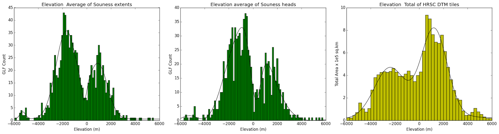
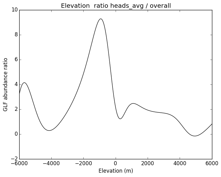
The elevation distribution looks as follows:
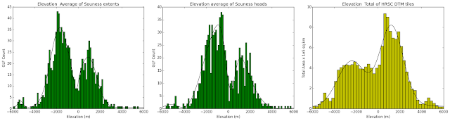 |
| Elevation histograms for Souness object extents and head areas, compared with the overall elevation distribution in the coverage of the HRSC DTM tiles used |
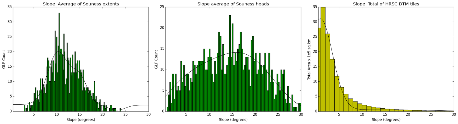
 |
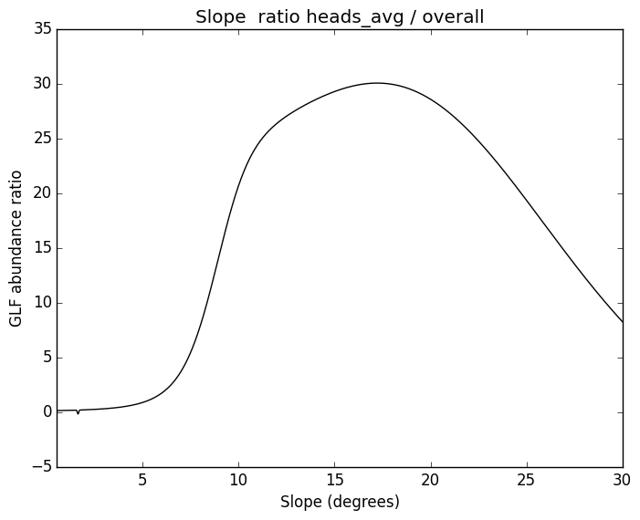
| Slope histograms for Souness object extents and head areas, compared with the overall slope distribution in the coverage of the HRSC DTM tiles used |
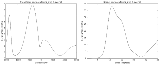 |
| Showing the ratio of the GLF distribution as a function of elevation and slope / elevation and slope distribution in the HRSC tiles for extents. |
 |
| The GLF distribution as a function of elevation / elevation distribution in the HRSC tiles for the head areas. |
 |
| The GLF distribution as a function of slope / slope distribution in the HRSC tiles for the head areas. |
I noted in the dissertation that that the numbers of glaciers appeared to be depleted below elevations of -3000m relative to Mars datum. There are two types of explanation for this, firstly that they were not formed, or secondly that they were more rapidly ablated. Fewer may have formed in the range -5000 to -3000 due to slope effects, with a large proportion of the these elevations being made up of the flat plains in the northern hemisphere, and the Martian glaciers are preferentially found on slopes. Alternatively in the higher-obliquity epoch, ablation may have been favoured at low elevations, due to higher temperatures, and possibly wind-stripping of debris cover allowing sublimation.
The outliers at the extreme ends of the elevation distribution may be of interest, since they may show something about what limited the distribution of Souness objects on Mars.
There is a secondary peak in the distribution at very low elevations. These could have formed at a later epoch at a lower obliquity in a cooler climate where glacier accumulation was only significant at the lowest elevations.
It is also an interesting question whether the objects at very high elevations formed at the same epoch as the main distribution, or whether these come from an older, more extreme obliquity epoch.
Lowest and highest 30 Souness glacier-like forms
Based on mean elevation of 5km circular radius buffer (from Souness et al. 2012 paper)
Lowest elevation 30 GLFs (buffer mean from Souness catalog):
Highest elevation 30 GLFs (buffer mean from Souness catalog):
Based on mean HRSC DTM elevation of immediate head area (100m radius)
Lowest elevation 30 GLFs (head):
Highest elevation 30 GLFs (head):
Nov 12, 2016
The shock victory of Gul Dukat and Liquidator Brunt in the galactic presidential election has left the Federation wondering if Earth will reconsider plans to leave the Federation following the
referendum in which the population narrowly voted to do so.
 |
| Although it is now eight Earth years since the Earth voted by 52% to 48% to leave the Federation, the President of Earth has not invoked Article 50 of the planet's membership treaty and is in battle over whether she can do so without a vote in the Planetary Assembly. The Earth orbital and lunar colonies strongly voted remain. The First Minister of Luna is advocating an independence referendum and several asteroid colonies are exploring transferring to Martian jurisdiction which has its own Federation membership. |
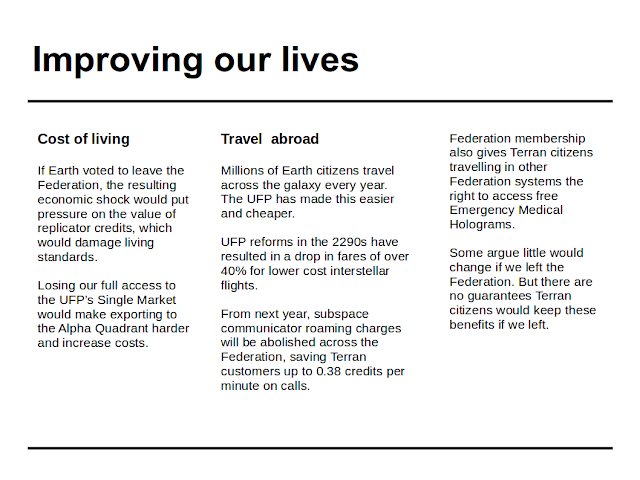 |
| Losing access to the Federation single market would make Earth more vulnerable to economic exploitation by the Ferengi. |
 |
| The Leave campaign is now widely regarded as overestimating the amount of dilithium contributed to the Federation budget by Earth. |
Nov 11, 2016
On the morning of the second day of the Boundary Commission for England and Cornwall's public hearings relating to the proposed new parliamentary constituencies including a Devonwall constituency, the government has published
what it calls a response to the recent petition to restore central government funding for the Cornish language.
 |
| I would attend one of the public hearings but I have already responded online and expect the public hearings to be a farce. The issue is not primarily with the Commission but the remit they were given by Government (see my comment on Dick Cole's blog). |
However this (non-)response is insulting because it doesn't address any of the issues raised regarding the status of Cornish as a recognised minority language. We are once again treated as second class citizens.
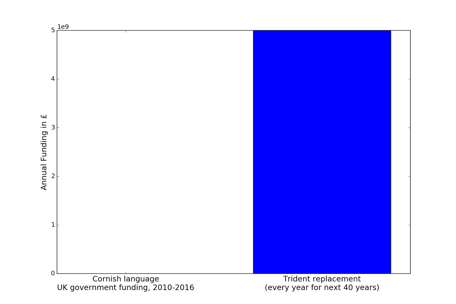
Here are a couple of bar graphs illustrating how much the UK government has been spending each year on the Cornish language in the years 2010 to 2016.
 |
| The blue bar is 1200 pixels high in the original image therefore the left hand bar (£108333.33/yr based on £650000 over 6 years) is not even visible in the rendering. It should also be noted that the UK government has funded nuclear weapons since the 1940s whereas the £650000 in 6 years represents the entirety of the UK central government funding for Cornish over more than 300 years since the 1707 Act of Union. |
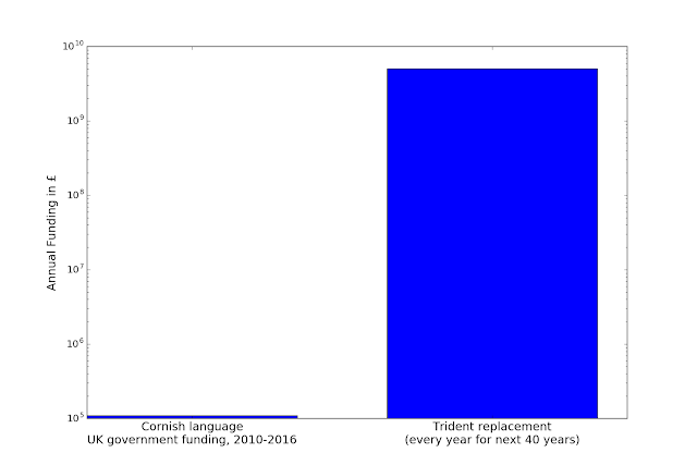 |
| Even on a logarithmic scale it still looks like peanuts. |
The government's response was so short I can quote it here in full:
The Government has provided Cornwall Council with substantial spending power to allocate resources to their local priorities, including the Cornish language.
Read the response in full
The Government has always been clear that its funding of some £650,000 since 2010 to support the development of the Cornish language was time-limited, and that the Council should seek alternative sources in order to place it on a more sustainable basis. Cornwall Council has a core spending power of £1.7 billion over four years from which they can allocate the necessary resources to local priorities, including the development the Cornish language, if they wish.
Department for Communities and Local Government
This doesn't address any of the issues raised related to the UK signing the
European Charter for Regional or Minority Languages or the
Framework Convention for the Protection of National Minorities. It is a non-response that can be described as insulting.
This "
substantial spending power" is on an annual basis not even 10% of the estimated annual budget for Trident replacement.
Meanwhile the
average full-time weekly wage in Kensington is £848.20 whereas in St. Ives constituency it is only £389.20, the 4th lowest in the UK tied with Dwyfor Merionydd. Where is this spending power of which you speak? When are you planning to close the income gap with London?
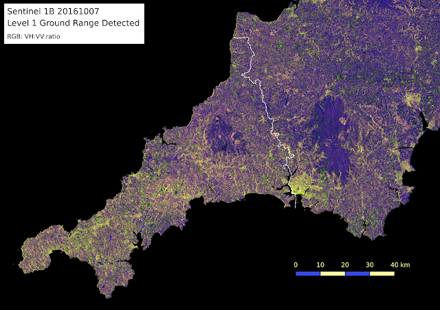
Oct 23, 2016
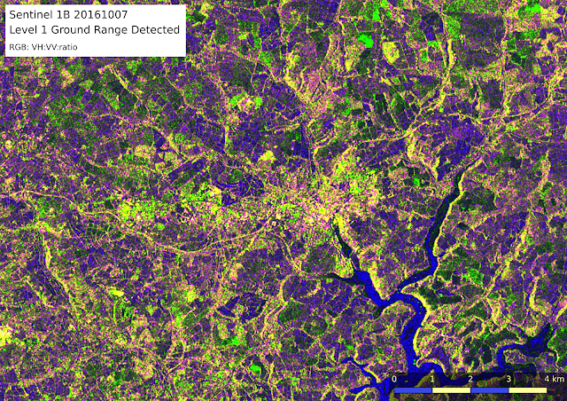
The European Space Agency operates the pair of
Sentinel 1 synthetic aperture radar satellites.
The advantage of radar is that it is not affected by clouds to the same degree that optical remote sensing is, and there is also useful information gained by the polarisation.
As an example, I downloaded a Sentinel 1B product covering Cornwall and Devon which was taken on 7th October 2016, from the
Copernicus data hub.
The type of product I used is the
Interferometric Wide Swath mode (
further detail).
I used the
Sentinel Toolbox to perform orthorectification automatically, and visualise as a RGB with VH polarisation in the red channel, VV in the green, and the ratio between the two in the blue.
 |
| Truro |
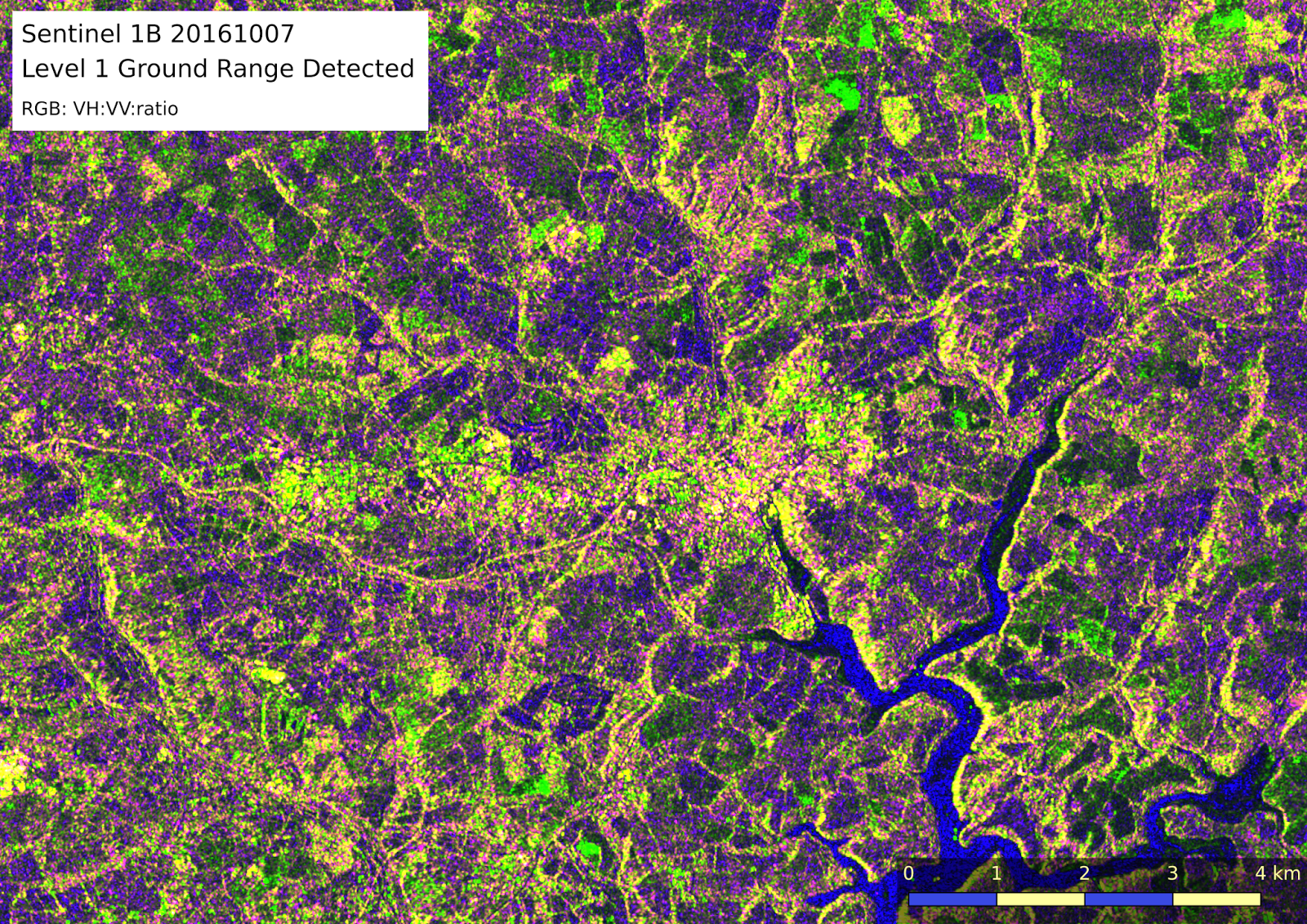
The
stripmap mode of aquisition, which is less commonly used, provides a higher resolutionof 5m x 5m.
Here is an image from 11th December 2014, with the same colour scheme used.
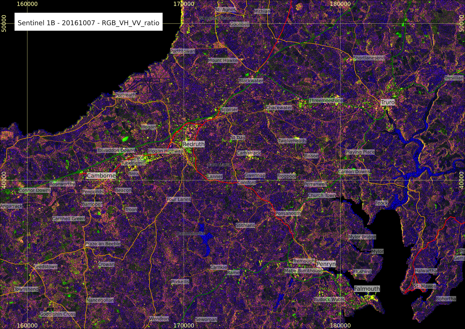
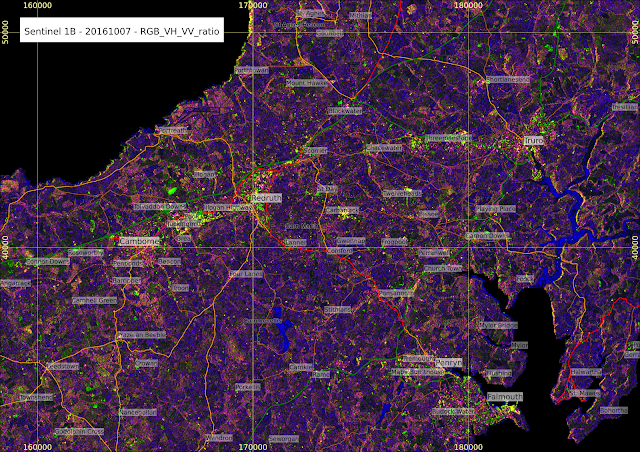 |
| Returning to the interferometric wide swath mode, overlaying roads and placenames for context. The colour scaling is slightly different in this image, making the green band less strong. |
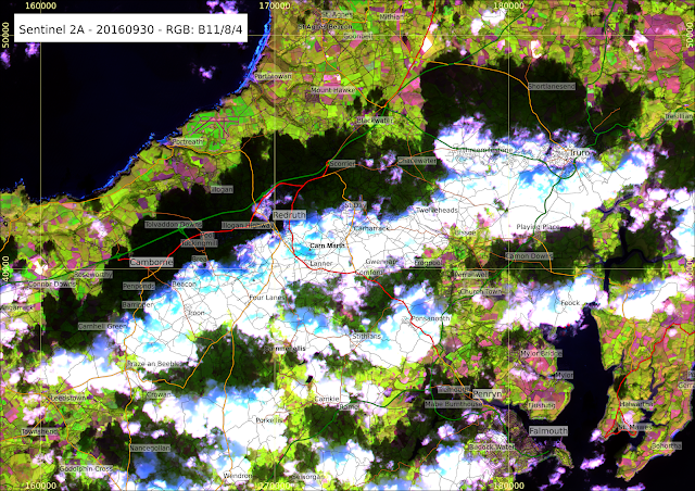 |
| A portion from a Sentinel 2A image from 30th September 2016, using bands 11, 8 and 4 (1610nm, 842nm, 655nm). |
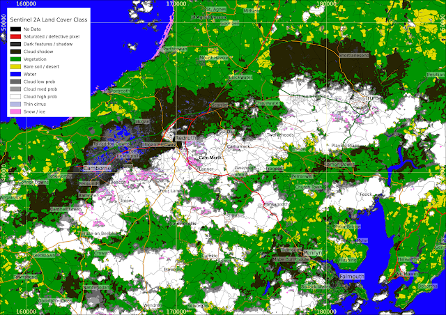 |
| The Level 2A product includes a basic pixel level land cover classification - there are some errors here note some cloud shadow has been classified as water or cloud, and spurious snow/ice around Porthtowan. |