Skrifennow
My blog, imported from Blogger and converted using Jekyll.
« Prev
1
2
3
4
5
6
7
8
9
10
11
12
13
14
15
16
17
18
19
20
21
22
23
24
25
26
27
28
29
30
31
32
33
34
35
36
37
38
39
40
41
42
43
44
45
46
47
Next »
Showing elevation and slope on a map for cycling
A while ago, I was thinking about making a map that showed elevation and slope by colour-coding. It is often conventional to show elevation with contours, or by some sort of arbitrary colour palette.
Slope is shown on a map usually by contours being closely spaced, or by arrows shown along roads in some cases. Contours can sometimes obscure map features in some cases.
An alternative approach I have used to produce, is to colour-code both elevation and slope simultaneously in different colour channels.
In the cases below, I have used the blue band for elevation, and red for slope. Since I intended this as a map for cycling I have named the different scalings after professional cyclists.
I give a few more examples of this using a different slope scaling and downloads of larger image files on my website.
Slope is shown on a map usually by contours being closely spaced, or by arrows shown along roads in some cases. Contours can sometimes obscure map features in some cases.
An alternative approach I have used to produce, is to colour-code both elevation and slope simultaneously in different colour channels.
In the cases below, I have used the blue band for elevation, and red for slope. Since I intended this as a map for cycling I have named the different scalings after professional cyclists.
 |
| Elevation shading colour codes elevations from 0-150m above sea level in the blue channel, and slope values from 0-10 degrees (up to 22.5%) in red. This map is optimised for lowland areas, however at higher elevations the direction of elevation change is no longer clearly shown on this map. |
 |
| Elevation shading colour codes elevations from 50-400m above sea level in the blue channel, optimising the map to show elevations in the higher part of the range. Slope values are shaded from 0-10 degrees (up to 22.5%) in the red channel as earlier. |
I give a few more examples of this using a different slope scaling and downloads of larger image files on my website.
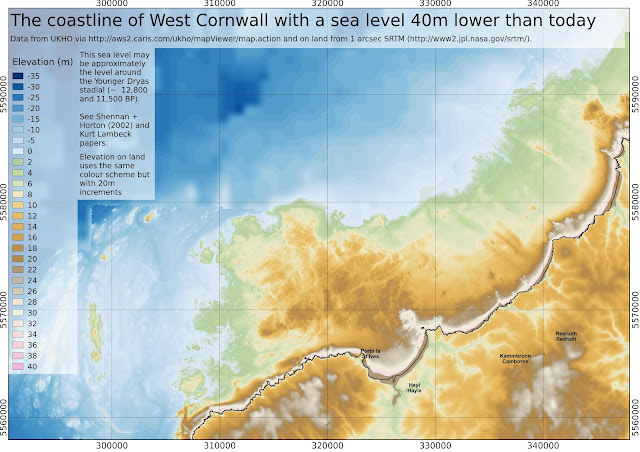
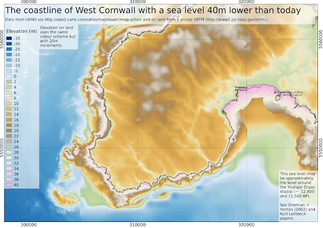
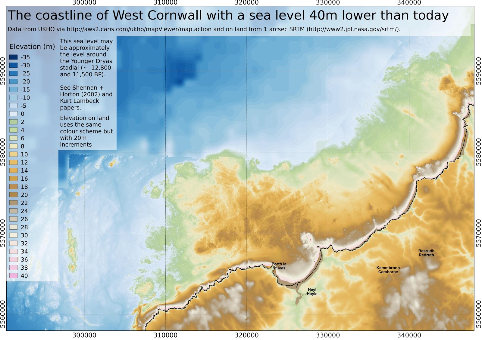
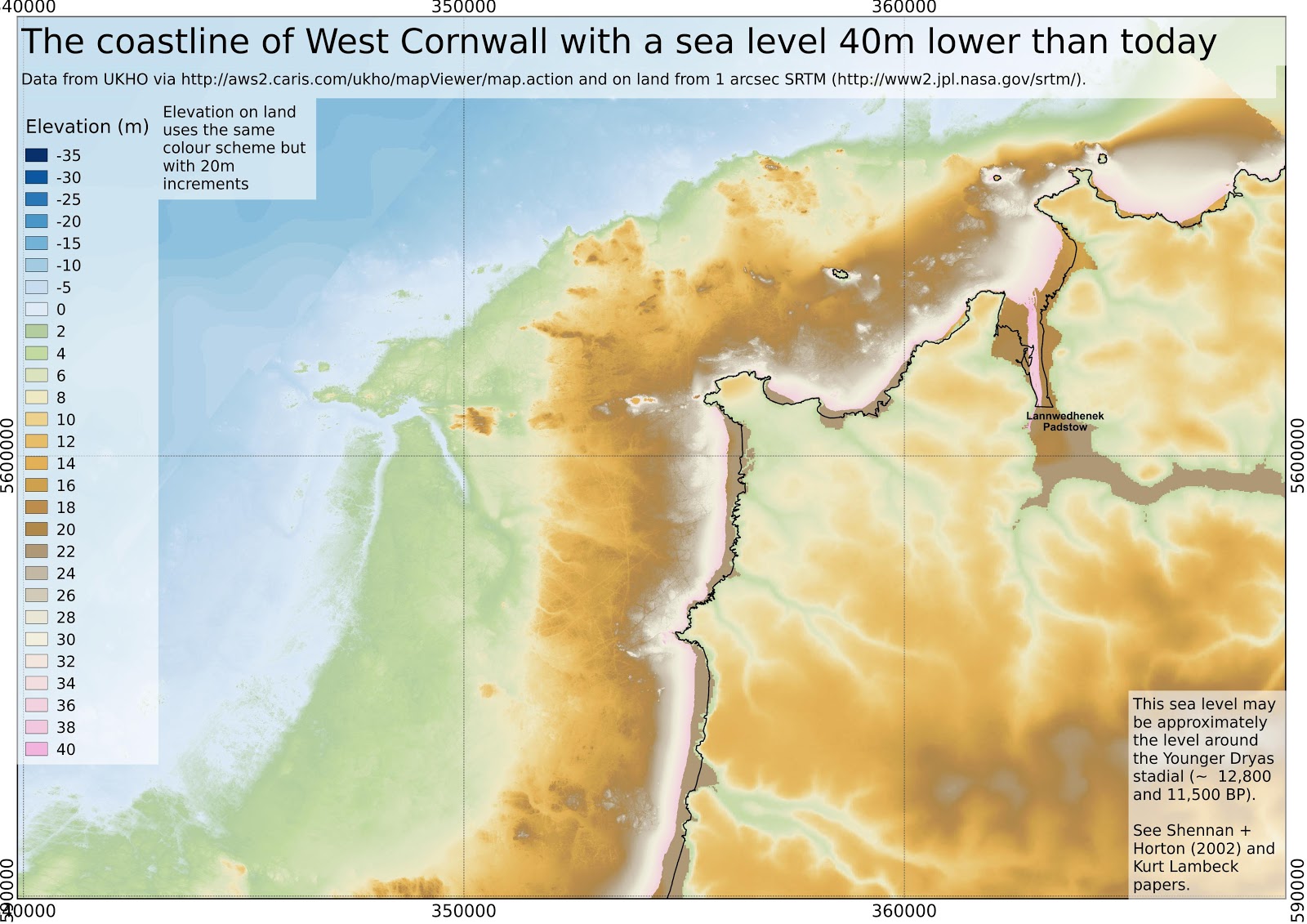
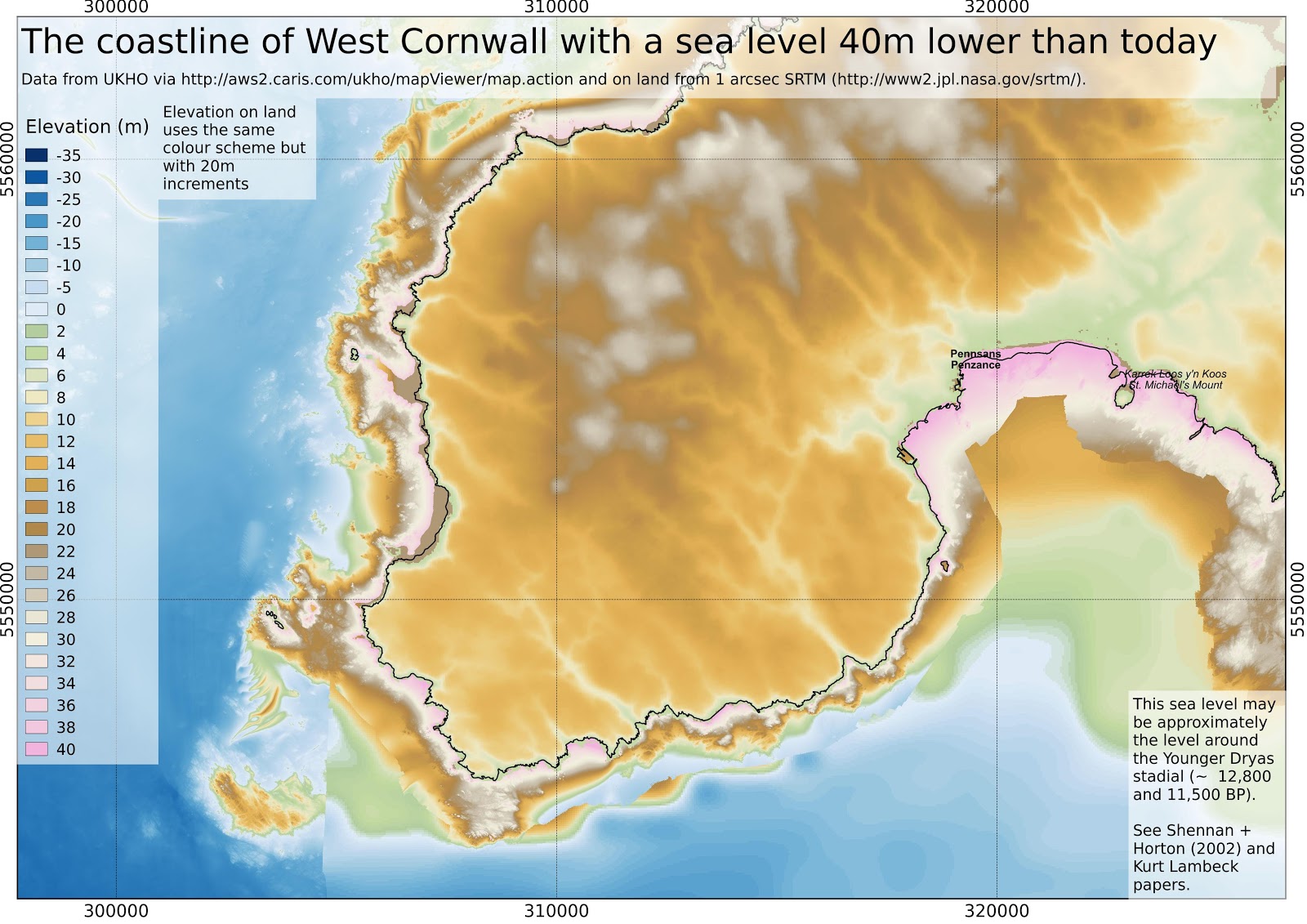
The Lost Land of Lyonesse - update with high resolution bathymetry
I found high resolution bathymetric data available via the INSPIRE portal from UK Hydrographic Office.
So I thought it time to update my previous post on the lost land of Lyonesse, off the coast of Cornwall.
I was interested to find out what sea level the first people to inhabit Britain in a post-glacial climate around the Younger Dryas stadial (12 kyr BP) may have encountered.
The bathymetry from the above link comes in small sections and not all areas have ready gridded data so there is a background from the General Bathymetric Chart of the Oceans which has a resolution of 30 arcseconds (about 600m here) but resampled to 48m/pixel for a less pixellated look.
For this reason, and also to not worry about differential post-glacial rebound across the area, I have concentrated on West Cornwall. I have used the same assumptions of it as my previous post on the subject, that is the Shennan + Horton 2002 paper primarily also referring to the work of Kurt Lambeck.
I have assumed that sea level was 40m lower 12kyr BP, 30m lower 10kyr BP, 2m lower 8kyr BP, 16m lower 7kyr ago, 12m lower 6kyr ago, and 7m lower 5kyr ago.
I have taken no account of sediment deposition/erosion after marine transgression.
I have accidentally labelled Universal Transverse Mercator zone 30N coordinates rather than Ordnance survey grid coordinates,the units are however still in metres.
The elevation shading restarts from zero for the land, but incrementing in 20m steps rather than 2m. The first shaded colour on land is light green at 40-60m (12kyr ago).
Let me know what you think in the comments.
 |
| In legend Lyonesse is supposed to have connected Cornwall to Scilly. We see above that this is not likely to have been the case in a post-glacial climate since there is deep water of > 70m below present sea level between Land's End and Scilly. However substantial areas in Mount's Bay and north of St. Ives would have been dry land, up to about 8 kyr ago (sea level assumed to be 20m below present). |
 |
| Unfortunately I don't currently have wide area gridded high-resolution bathymetry around Scilly. The inundation of the area between the currently inhabited islands occurred rather later than would be indicated by the labelling of this map, since this is known to have been dry land in historical times. |
 |
| Close-up of area north of St. Ives and Hayle. A relatively large area of land would be been likely to have been submerged between about 9kyr and 7kyr ago. |


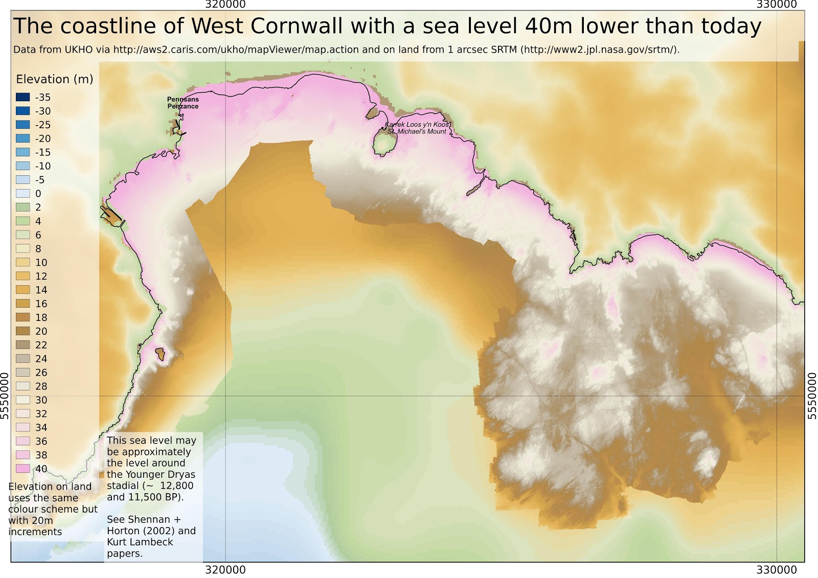 |
| The Cornish name for St. Michael's Mount, Karrek loos y'n koos, means 'the grey rock in the woods'. At 5kyr ago, sea level is assumed to be 7m below present (i.e the pink land). |
 |

 |
| A bit of artistic licence, imagining vegetation colonising the lowlands, with the uplands still sparse at this stage (shortly after Younger Dryas 12-11yr ago) |
Greeting the user in Cornish for #speakcornish week
The events of #speakcornish week, an initiative of MAGA Kernow (The Cornish Language Partnership) along with other Cornish language organisations, have been taking place over the past week.
The way to greet someone in Cornish, depends on the time of day, with Myttin da for "Good morning", Dohajydh da for "Good afternoon" etc.
I have written a Python module to greet the user according to the time of day, at the console. It is available at my Bitbucket account or alternatively below:
The way to greet someone in Cornish, depends on the time of day, with Myttin da for "Good morning", Dohajydh da for "Good afternoon" etc.
I have written a Python module to greet the user according to the time of day, at the console. It is available at my Bitbucket account or alternatively below:
# gorhemmyn_kw.py
# David Trethewey
# 11-07-2015
# skrifys rag #speakcornish week 2015
import time
class Gorhemmyn:
# py termynyow a wra chanjya
# furv an gorhemmynadow
bora = 3
myttin = 7
dydh = 11
dohajydh = 14
gorthugher = 18
nos = 23
def __init__(self):
t = time.localtime()
our = t.tm_hour
self.gorhemmyn = "Dydh da" # default
if our >= Gorhemmyn.nos or our < Gorhemmyn.bora:
self.gorhemmyn = "Nos da"
if our >= Gorhemmyn.bora and our < Gorhemmyn.myttin:
self.gorhemmyn = "Bora da"
if our >= Gorhemmyn.myttin and our < Gorhemmyn.dydh:
self.gorhemmyn = "Myttin da"
if our >= Gorhemmyn.dydh and our < Gorhemmyn.dohajydh:
self.gorhemmyn = "Dydh da"
if our >= Gorhemmyn.dohajydh and our < Gorhemmyn.gorthugher:
self.gorhemmyn = "Dohajydh da"
if our >= Gorhemmyn.gorthugher and our < Gorhemmyn.nos:
self.gorhemmyn = "Gorthugher da"
def pryntya(self):
print(self.gorhemmyn)
if __name__ == "__main__":
g = Gorhemmyn()
g.pryntya()
Ebrenn y'n Nos - mis-Gortheren 2015
Ottomma skrif a'n kynsa rann yn kevres a wrav vy gul rag Radyo An Gernewegva, a-dro dhe'n ebrenn y'n nos ha hwilans spas. An rekordyans o darlesys yn rann 229 o RAnG. Drog yw genev yth esa neb si yn keyndir an rekordyans, yth esa neb kaletter gans ow korrgowser dell dybav.
This is a transcript of the first part of a series I am doing for Radyo An Gernewegva about the night sky and space exploration. It was broadcast in episode 229 of RAnG.
Dydh da. Davydh Trethewey ov vy. My a vynn gul kevres nowydh yn Radyo an Gernewegva a wra dismygi dhywgh hwi pub mis a-dro dhe'n ebrenn nos. My a wra leverel pyth a yllowgh gweles yn ebrenn nos, ha nowodhow a-dhiworth an bys steronieth ha hwilans spas.
Yn mis-Gortheren an nosow yw berr. Yn Truru, dy' Kalann Gortheren, an howlsedhes yw 21:34, amser hav Predennek, ha'n howldrevel yw 05:14. Yma tri sort a mo (po twilight yn Sowsnek): mo sivil, mo morek, ha mo steroniethel. Yn dalleth mis-Gortheren, mo steroniethel a bes dres oll an nos, ha ny wra hi mos tewl yn ewn vyth oll. An nosow a hirha dres an mis, ha'n diweth an mis bydh an howldrevel 05:47 ha'n howlsedhes 21:06, hag y fydh tri our tewlder ewn ynter 23:45 ha 03:09. Mars os ta yn neb le arall yn-mes Kernow, hwi a yll kavos an termynyow ma diworth www.heavens-above.com
A-dhistowgh wosa an howl a sedh, hwi a yll gweles an planetys Gwener ha Yow y'n west. Yn gorthugher 30ves mis-Metheven, an dew blanetys a wra neshe y'n ebrenn, bys dhe tressa rann degre, le es braster gwelys an loor, kyn ny wrons i bos yn keth le yn spas.
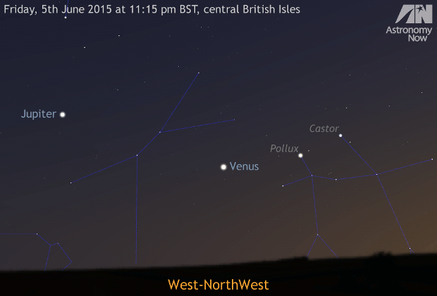 |
| Imaj: Gwiasva Astronomy Now |
Gwener yw an splanna anedha, mes nyns yw possybl gweles travyth warnedhi awos an kommol oll a-dro dhedhi. Yn pellweler, yth yw hi gwelys avel gwarak gwynn. Drefenn hi dhe mos ynter an howl ha'n norvys 15ves mis-Est, hi a wra brashe, mes an gwarak a danowha. An moyha splannder dhe Wener yw nos 12ves mis-Gortheren. Gwener yw an splanna taklenn yn ebrenn nos, marnas an loor.
Yow yw gorherys yn kommol ynwedh, mes yn pellweler y hyll bos gwelys grogysow kommol warnodho, tewedh bras (An Namm Rudh Meur), ha peswar a'y loryow. Yow a wra mos anweladow yn skon, drefenn ev dhe mos bys dhe du arall an howl ha ni, ha ny wra ev bos gwelys y'n ebrenn nos. Ev a wra henna 26ves mis-Est ha wosa henna dasomdhiswedhes y'n ebrenn bora. An planet Meurth yw tu arall dhe'n howl ynwedh hag anweladow lemmyn.
Sadorn yw gweladow isel yn soth yn ranneves Libra, wosa hi a dewlhe. An bysowyer Sadorn yw gweladow yn pellweler, hag ynwedh loor Titan ha nebes an huni byghanna.
Y fydh an loor leun dhe'n 2a mis-Gortheren, kwartron diwettha an 8ves mis-Gortheren, loor nowydh an 16ves mis-Gortheren ha kynsa kwartron an 24ves mis-Gortheren. Y fydh an loor leun arta dhe'n 31ves mis Gortheren.
Yth esa diskwedhyans Golowys an Kledhbarth an 22a mis-Metheven. Ny wrons i gweles yn fenowgh diworth le mar soth avel Kernow, mes nebonan diworth Lanndreth a's gwelas ha miroryon erell a'n Ruvaneth Unys. Mirewgh orth an wiasva www.flickr.com/groups/aurorawatch/ po sywyewgh @aurorawatchuk war Twitter dhe kavos gwarnyans diskwedhans aurora.
Yma meur a nowodhow dhe vri a-dro dhe hwilans spas y'n mis ma.
An efanvos Rosetta diworth Asienteth Spas Europ a wrug drehedhes an komet Churyumov-Gerasimenko yn mis-Du diwettha, mes y direll Philae a wrug aslamma ha tira yn maner nag esa lowr a wolow howl dhe nerthhe hy panelys howl. Y hwre an komet na neshe an howl yn misyow diwettha, ha krefter an howl a dheth ha bos lowr dhe dhifuna an direll ha'y dannvonn sinell bys dhe'n resegvell ha'n norvys. Dell hevel y hwra bos possybl dhe'n direll gul an ober godhonieth a vynnons an godhoniethoryon y wul.
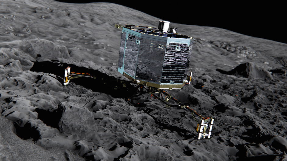 |
| Philae. kevrenn |
An efanvos “Gorwelyow Nowydh” (New Horizons) a wra neyja dres Pluton 14ves mis-Gortheren. An efanvos na o lonchys nans yw dewdhek blydhen, yn 2003, ha neyja dres planet Yow war y fordh dhe Bluton. Hag ev war y fordh, Pluton o dasklassys avel “planet korr” a-der “planet” wosa diskudhans taklennow erell yn grogys Kuiper kepar hag Eris hag erell. Ny wra an efanvos na mos yn resegva a-dro dhe Bluton, drefenn ev dhe neyja re uskis dhe hedhi. Kyn fia an dresneyjans termyn berr, y hwra iskargans an data pur lent, y hwra durya bys dhe martesen 18 mis wosa an dresneyjans dhe dhannvon an data dhe'n norvys, awos pellder meur dhe Bluton, ogas dhe 3 bilvil mildir. An negys "Goonhilly Earth Station Limited" a vynn usya an lestri radyo bras dhe Woonhelghya yn Kernow dhe geskommunya orth efanvosow ynterblanetek y'n termyn a dheu.
Godhonydhyon a wrug usya efanvos “Ekspress Gwener” (Venus Express) dhe diskudha yma loskvenydhow byw war Wener, dre weles nammow-poth yn is-rudh, hag y hwrussons i dyllo paper yn y gever seulabrys.
An efanvos Cassini re beu ow resegva a-dro dhe Sadorn wosa ev dh'y dhrehedhes yn 2003. Yma hwath imajys nowydh diworto a loryow Sadorn kepar ha Dione, loor a vraster kepar ha Pow Frynk, a wrug Cassini dresneyja 16ves mis-Metheven ha gweles kilnansow bras, ha Titan gans lynnow hidrokarbons warnodho.
 |
| Lynnow war enep Titan. kevrenn |
My a wayt bos an gewer da ha'n nosow kler y'n mis ow tos ha ni a yll gweles neppyth dhe les y'n ebrenn. Bys nessa prys.
A little more on the "omission error" for the woodland areas
To have a bit more of a look at the areas that are woodland in OS VectorMap and not classed as woodland in the classification, I here show where these areas are on the satellite images, and the classes that these areas are in fact assigned.
June 2006
 |
| Showing the areas indicated as woodland in OS VectorMap but not by the classification outlined in black, overlaid on the Landsat 7 image from 9th June 2006 (bands 5,4,3). large version |
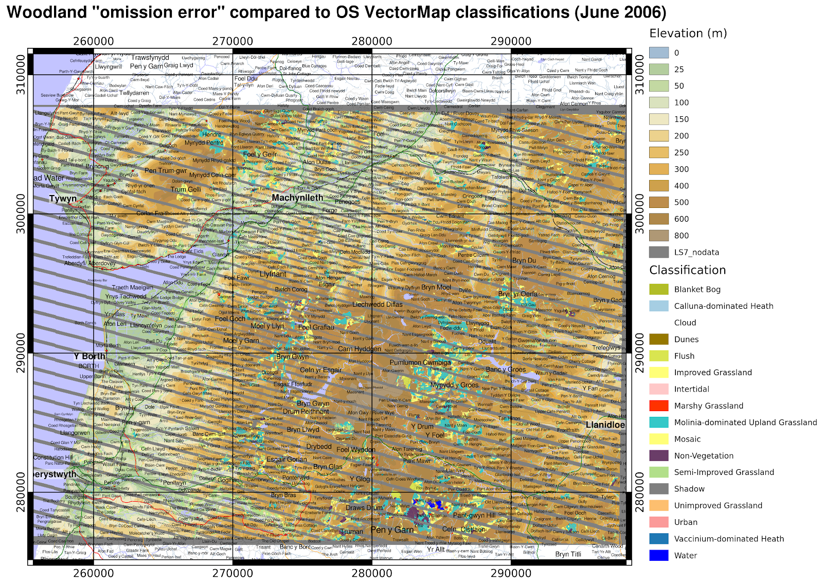 |
| Showing the actual classifications the "omission error" areas were assigned. large version |
March 2007
 |
| Showing the areas indicated as woodland in OS VectorMap but not by the classification outlined in black, overlaid on the Landsat 7 image from 24th March 2007 (bands 5,4,3). large version |
 |
| Showing the actual classifications the "omission error" areas were assigned. larger version |
September 2013
 |
| Showing the areas indicated as woodland in OS VectorMap but not by the classification outlined in black, overlaid on the Landsat 8 image from 24th September 2013 (bands 6,5,4). Some areas that display in pink here appear to be recently felled forest areas that have a weak reflectance in NIR (shown in green), but strong in SWIR1 (shown in red) with some reflectance in red (shown in the blue channel here). large version |
 |
| Showing the actual classifications the "omission error" areas were assigned, and the 'cloud' areas. Some shaded areas are spuriously being classified as water. large version |
« Prev
1
2
3
4
5
6
7
8
9
10
11
12
13
14
15
16
17
18
19
20
21
22
23
24
25
26
27
28
29
30
31
32
33
34
35
36
37
38
39
40
41
42
43
44
45
46
47
Next »